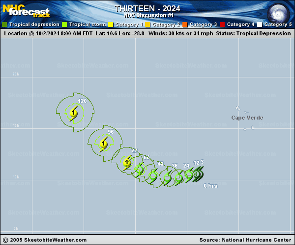
Official Discussion issued by the National Hurricane Center
Thirteen (AL132024) DATA RELEASED: 10/2/2024 2:00:00 PM UTC
|
Copy of official data Tropical Depression Thirteen Discussion Number 1 NWS National Hurricane Center Miami FL AL132024 200 PM CVT Wed Oct 02 2024 The system we have been monitoring several hundred miles to the southwest of the southernmost Cabo Verde Islands has become gradually better organized this morning with some curved bands organizing to the west of the estimated center. Visible satellite images show that at least a broad closed circulation has developed. Based on the latest subjective Dvorak fixes of T2.5/35-kt from TAFB and T1.5/25-kt from SAB, advisories are being initiated on Tropical Depression Thirteen, with an initial intensity in between these estimates at 30 kt. The depressions initial motion appears to be slowly due west, at 270/6 kt. Over the next day or two this motion should continue, though some of the track guidance actually shows a south of due west motion, partially related to the steering flow and also the possibility that the center might try to reform underneath deep convective bursts in the southern semicircle. After 48 h, the guidance shows TD13 turning west-northwestward and then northwestward by the end of the forecast as mid-level ridging becomes more eroded on its northwestern side while a large long-wave trough becomes established over the Northwest Atlantic. The initial NHC track forecast has opted to favor a track close to the consensus aid TVCN. Interestingly, both the GFS and ECMWF are on the east side of the guidance, while HCCA is on the western side by the end of the forecast period. Intensity wise, initial strengthening could be on the slower end, as the system has to deal with some northwesterly shear related of the outflow from the much larger Hurricane Kirk impinging upon the system. However, the guidance insists this shear will soon decrease, especially after 24-36 h where the upper-level flow seems to split off into a cutoff low to the southwest, and a upper-level trough that shifts east of the depression, leaving the depression in a more favorable upper-level diffluent pattern. After TD13's inner core become better defined, the rate of intensification could increase after 36 h, and the latest NHC intensity forecast forecasts the depression to become a hurricane in 3 days. Additional intensification is forecast after that point as long as the cyclone tracks far enough away from the cold ocean wake left behind by Kirk. This forecast is roughly in the mean of the intensity guidance envelope. FORECAST POSITIONS AND MAX WINDS INIT 02/1500Z 10.6N 29.1W 30 KT 35 MPH 12H 03/0000Z 10.5N 29.8W 35 KT 40 MPH 24H 03/1200Z 10.2N 30.8W 40 KT 45 MPH 36H 04/0000Z 10.2N 31.9W 45 KT 50 MPH 48H 04/1200Z 10.4N 33.3W 55 KT 65 MPH 60H 05/0000Z 11.0N 34.6W 60 KT 70 MPH 72H 05/1200Z 11.7N 35.8W 65 KT 75 MPH 96H 06/1200Z 13.5N 38.1W 75 KT 85 MPH 120H 07/1200Z 16.5N 41.0W 80 KT 90 MPH $$ Forecaster Papin |