Official Discussion issued by the National Hurricane Center
Seven (AL072024) DATA RELEASED: 9/11/2024 2:00:00 PM UTC
|
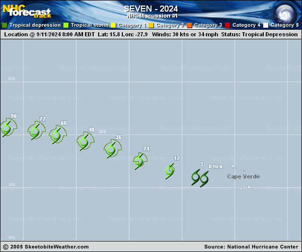
Copy of official data Tropical Depression Seven Discussion Number 1 NWS National Hurricane Center Miami FL AL072024 Issued by the NWS Weather Prediction Center College Park MD 200 PM CVT Wed Sep 11 2024 Tropical Depression Seven has formed in the eastern Atlantic today. This formation is based on scatterometer depicting a closed circulation center, and organized deep convection based on TAFB/SAB satellite classifications. Satellite imagery also indicates that the low-level circulation has consolidated beneath the mid-level center based upon visible imagery The initial intensity is set to 30 kt, based on the scatterometer data. The depression is estimated to be moving 285/16 kt. The system should move to the west or west-northwest over the next few days with the storm being steered by a subtropical ridge to the north of the Azores. Confidence in the depression's track gradually lessens beyond forecast hour 72 as the synoptic scale flow becomes more complex. The depression will probably gradually slow down between hours 72-120 as it becomes caught between a pair of upper level ridges; one north of the Azores and another north of the Lesser Antilles. Meanwhile, an amplifying upper trough in the North Atlantic will attempt to deepen far enough south to steer the depression northward. How much the upper trough digs southward will determine if and when the storm takes on a more northerly track, or if it remains at a lower latitude longer. The forecast was placed just south of consensus this forecast period. Wind shear is not expected to be a big hindrance in its development initially while SSTs along its forecast path will generally be around 27C. Thus gradually intensification is shown for the first couple of days. However, shear is forecast to increase thereafter along with more marginal dry air conditions. This forecast leans more heavily on the regional hurricane models which show more modest intensification than the statistical dynamical tools but could be conservative at the end depending on how much latitude the system gains. FORECAST POSITIONS AND MAX WINDS INIT 11/1500Z 16.0N 28.7W 30 KT 35 MPH 12H 12/0000Z 16.6N 31.2W 35 KT 40 MPH 24H 12/1200Z 17.5N 34.1W 40 KT 45 MPH 36H 13/0000Z 18.6N 36.7W 45 KT 50 MPH 48H 13/1200Z 19.3N 39.3W 45 KT 50 MPH 60H 14/0000Z 19.9N 41.9W 45 KT 50 MPH 72H 14/1200Z 20.3N 43.9W 45 KT 50 MPH 96H 15/1200Z 20.6N 46.6W 45 KT 50 MPH 120H 16/1200Z 21.0N 48.8W 45 KT 50 MPH $$ Forecaster Mullinax/Blake |