|
HURRICANE RELIEF:
1-800-HELP-NOW
AMERICAN
RED CROSS
Click here to view the Forecast/Discussion archive for this storm
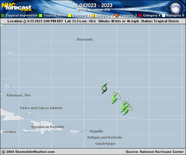
Remnants Of Cindy Discussion Number  16
NWS National Hurricane Center Miami FL       AL042023
1100 PM AST Sun Jun 25 2023

Satellite imagery this evening shows that the low-cloud swirl
associated with Cindy has again become void of deep convection.  In
addition, imagery animation and scatterometer data indicates that
the system no longer has a closed circulation.  Thus, the cyclone
has degenerated to a tropical wave or trough and this will be the
last advisory.  The initial intensity is set to 35 kt based on the
scatterometer data and satellite intensity estimates from TAFB and
SAB, and it is anticipated that the maximum winds will drop below
tropical-storm force during the next several hours.

The initial motion is 315/12.  The remnants of Cindy should
continue a general northwestward motion for the next couple of
days, and then turn northward on the eastern side of a deep-layer
baroclinic trough over the eastern United States and the western
Atlantic.

In the short term, there is little chance of any regeneration due
to continued southwesterly vertical shear.  However, after 48 h or
so, the shear should diminish, and there is a chance that Cindy
could regenerate after that time near or north of Bermuda.
However, the model support for this has decreased over the last 24
h, and currently there is not enough confidence in regeneration to
explicitly show it in the forecast.

This is the last advisory on Cindy by the National Hurricane
Center. Additional information on this system can be found in High
Seas Forecasts issued by the National Weather Service, under AWIPS
header NFDHSFAT1, WMO header FZNT01 KWBC, and online at
ocean.weather.gov/shtml/NFDHSFAT1.php


FORECAST POSITIONS AND MAX WINDS

INIT  26/0300Z 22.8N  60.0W   35 KT  40 MPH
12H  26/1200Z...DISSIPATED

$$
Forecaster Beven
 | 