Official Discussion issued by the National Hurricane Center
Vicky (AL212020) DATA RELEASED: 9/15/2020 3:00:00 PM UTC
|
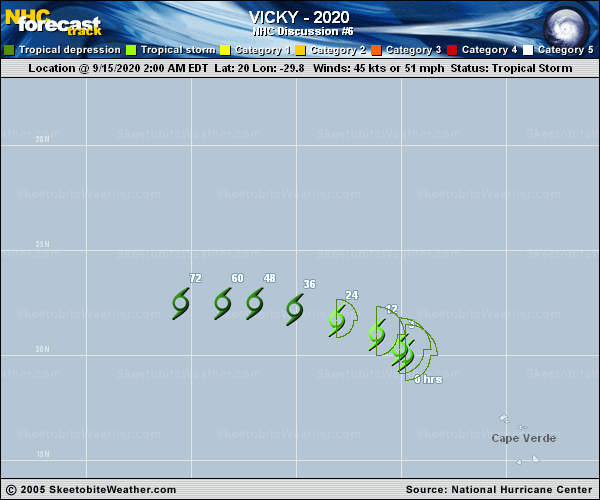
Copy of official data Tropical Storm Vicky Discussion Number 6 NWS National Hurricane Center Miami FL AL212020 1100 AM AST Tue Sep 15 2020 Although the stiff westerly shear (magnitude of greater than 50 kt) continues to affect Vicky's vertical structure this morning, a 1107 UTC METOP-B scatterometer pass indicated that the cyclone is maintaining 45-kt sustained winds well to the east-northeast of the center. Therefore, once again for this advisory, the initial intensity is held at 45 kt. The ECMWF/FV3 SHIPS intensity models and the deterministic guidance, including the simulated infrared imagery product, agree with Vicky weakening to a remnant low in 36 hours and dissipating by 72 hours due to the persistent strong shear. The initial motion is estimated to be west-northwestward, or 295/8 kt. Vicky is forecast to continue on this general motion through Wednesday night within the low-level tradewind flow. No significant changes were made to the previous advisory, and the new NHC forecast is based on the HCCA and TVCA consensus aids. FORECAST POSITIONS AND MAX WINDS INIT 15/1500Z 20.6N 31.0W 45 KT 50 MPH 12H 16/0000Z 21.3N 32.1W 40 KT 45 MPH 24H 16/1200Z 21.9N 34.0W 35 KT 40 MPH 36H 17/0000Z 22.3N 36.0W 30 KT 35 MPH...POST-TROP/REMNT LOW 48H 17/1200Z 22.2N 38.0W 30 KT 35 MPH...POST-TROP/REMNT LOW 60H 18/0000Z 22.2N 39.8W 25 KT 30 MPH...POST-TROP/REMNT LOW 72H 18/1200Z...DISSIPATED $$ Forecaster Roberts |