Official Discussion issued by the National Hurricane Center
Vicky (AL212020) DATA RELEASED: 9/17/2020 3:00:00 PM UTC
|
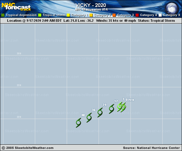
Copy of official data Tropical Depression Vicky Discussion Number 14 NWS National Hurricane Center Miami FL AL212020 1100 AM AST Thu Sep 17 2020 Vicky is feeling the affects of very strong upper-level winds associated with the outflow of Hurricane Teddy. These winds have caused the remaining convection to be stripped well away from the center, and recent ASCAT data indicates that Vicky has weakened to a tropical depression. The ASCAT data support a peak wind speed of 30 kt. Vertical wind shear of 40-50 kt is forecast to continue plaguing Vicky, and the cyclone should continue to weaken and become a remnant low later today. The global models indicate that the circulation will open up into a trough within 36 to 48 hours, and the official forecast calls for dissipation within that time period. Now that Vicky has become a vertically shallow cyclone, it has turned south of due west and is moving 260/12 kt. Vicky or its remnants should turn west-southwestward later today as it is steered by the low-level northeasterly flow. The latest NHC track forecast is in best agreement with the HFIP corrected consensus model. FORECAST POSITIONS AND MAX WINDS INIT 17/1500Z 21.4N 38.2W 30 KT 35 MPH 12H 18/0000Z 21.0N 39.6W 25 KT 30 MPH...POST-TROP/REMNT LOW 24H 18/1200Z 20.4N 41.3W 25 KT 30 MPH...POST-TROP/REMNT LOW 36H 19/0000Z 19.6N 43.0W 20 KT 25 MPH...POST-TROP/REMNT LOW 48H 19/1200Z...DISSIPATED $$ Forecaster Brown |