Official Discussion issued by the National Hurricane Center
Twenty (AL202020) DATA RELEASED: 9/13/2020 3:00:00 PM UTC
|
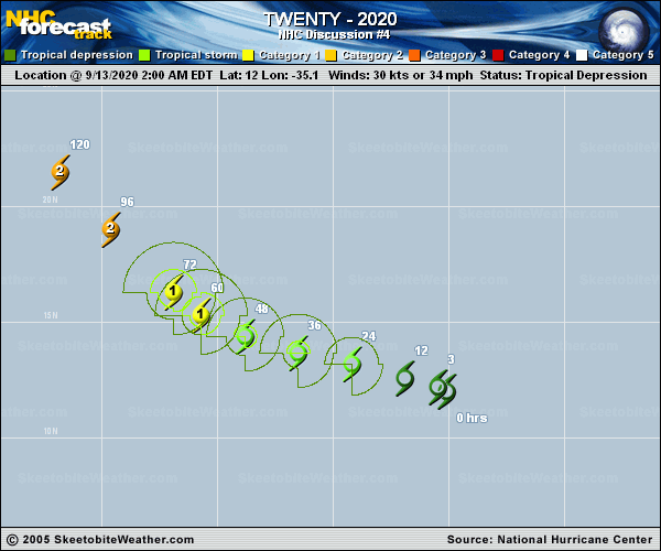
Copy of official data Tropical Depression Twenty Discussion Number 4 NWS National Hurricane Center Miami FL AL202020 1100 AM AST Sun Sep 13 2020 Convective banding features are generally limited to the southern semicircle of the circulation with the center exposed just to the north. A recent ASCAT pass indicated that the strongest winds--up to 30 kt--were primarily located in the southerly and southwesterly monsoonal flow trailing the depression, although some stronger winds are beginning to develop just west of the center. Light-to- moderate northerly shear is currently affecting the depression, but this shear is expected to decrease during the next 24-48 hours. In addition, global model fields indicate that the cyclone should become increasingly separated from the ITCZ/monsoon trough. Steady strengthening is anticipated for much of the forecast period, and the NHC intensity forecast closely follows the HCCA aid and the IVCN intensity consensus. This new forecast is a little higher than the previous prediction, especially on days 3 through 5. There are two main points that suggest this forecast could potentially go even higher in later forecast cycles: 1. the HWRF model shows more significant strengthening at the latter part of the period, bringing the system to major hurricane strength, and 2. the SHIPS Rapid Intensification guidance indicates that there is a 50-50 chance that the system will strengthen by at least 65 kt over the next 3 days, which is 9-10 times higher than the climatological mean. The depression is moving west-northwestward (290/9 kt) to the south of a large mid-tropospheric high centered over the central subtropical Atlantic. This feature should continue to drive the cyclone westward or west-northwestward for the next 2-3 days. After that time, the mid-level high is expected to shift northward and elongate, and the potentially intensifying hurricane is likely to acquire more poleward motion, moving northwestward and a little slower on days 3-5. Most of the track models are clustered close together, except for the HWRF which has a trajectory farther to the south and west. The new NHC track forecast has been shifted a bit westward compared to the previous prediction, close to the GFS-ECMWF consensus but not as far to the left as the latest TVCA and HCCA solutions. FORECAST POSITIONS AND MAX WINDS INIT 13/1500Z 12.3N 36.4W 30 KT 35 MPH 12H 14/0000Z 12.8N 38.0W 35 KT 40 MPH 24H 14/1200Z 13.3N 40.6W 45 KT 50 MPH 36H 15/0000Z 13.7N 43.0W 55 KT 65 MPH 48H 15/1200Z 14.4N 45.1W 65 KT 75 MPH 60H 16/0000Z 15.3N 46.7W 75 KT 85 MPH 72H 16/1200Z 16.3N 48.2W 85 KT 100 MPH 96H 17/1200Z 19.0N 51.0W 95 KT 110 MPH 120H 18/1200Z 22.0N 53.5W 95 KT 110 MPH $$ Forecaster Berg |