Official Discussion issued by the National Hurricane Center
Teddy (AL202020) DATA RELEASED: 9/18/2020 3:00:00 PM UTC
|
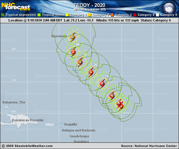
Copy of official data Hurricane Teddy Discussion Number 25 NWS National Hurricane Center Miami FL AL202020 1100 AM AST Fri Sep 18 2020 There was little change to the structure of Teddy since early this morning up until the past hour or so, when the eye began to fill in slightly while the cloud tops over the southern portion of the circulation warmed a bit. However, new convection with very cold cloud tops near -80 degrees C have developed recently over the northwestern quadrant, so the cyclone could just be undergoing a temporary intensity fluctuation that typically occurs in powerful hurricanes. The latest Dvorak intensity estimates range from 102 kt to 116 kt, and the initial intensity is being held at 115 kt for this advisory. There will be staggered NOAA and U.S. Air Force Reserve Hunter aircraft investigating Teddy starting this morning and continuing into the late afternoon, so they will soon be able to provide updated details on the latest structure, size, and intensity of the hurricane. The major hurricane continues to move northwestward, now at 10 kt. Teddy is expected to remain on that general course during the next couple of days as it moves on the southwestern periphery of a mid-level ridge. By the end of the weekend, when Teddy will likely be approaching Bermuda, a turn to the north or north-northeast is forecast to occur as a mid- to upper-level trough moves off the northeastern U.S. coast. Early next week, the trough is expected to cut off, causing Teddy to turn slightly to the left and approach Nova Scotia in 4 to 5 days. The models continue to be in good agreement on this scenario, and only small adjustments were made to the previous forecast track. Teddy will likely fluctuate in intensity over the next day or so while it remains in favorable conditions of low wind shear, warm waters, and a fairly moist air mass. By late this weekend, the hurricane is forecast to traverse over cooler waters churned up by Paulette last week. This should cause a weakening trend to begin. By Monday night, vertical wind shear is expected to drastically increase ahead of the approaching mid-latitude trough. This should not only weaken Teddy, but begin its transition to a large extratropical cyclone, and that transition should be completed before the end of the forecast period. The latest NHC intensity forecast is near the HFIP corrected consensus aid HCCA through 36 h, and then trends toward the SHIPS and LGEM intensity guidance thereafter. Teddy is producing a large area of high seas. The latest maximum seas estimated by TAFB near the core of the hurricane are near 45 feet. Swells from Teddy are spreading far from the center, see Key Messages below. Key Messages: 1. Teddy is expected to approach Bermuda as a hurricane this weekend and make its closest approach to the island late Sunday or Monday. While the exact details of Teddy's track and intensity near the island are not yet known, there is a risk strong winds, storm surge, and heavy rainfall on Bermuda, and watches may be issued later today or tonight. 2. Large swells produced by Teddy are expected to affect portions of the Leeward Islands, the Greater Antilles, the Bahamas, Bermuda, and the southeastern United States during the next few days. These swells could cause life-threatening surf and rip current conditions. FORECAST POSITIONS AND MAX WINDS INIT 18/1500Z 22.1N 56.1W 115 KT 130 MPH 12H 19/0000Z 23.3N 57.2W 115 KT 130 MPH 24H 19/1200Z 25.2N 58.9W 115 KT 130 MPH 36H 20/0000Z 27.1N 60.7W 110 KT 125 MPH 48H 20/1200Z 28.7N 62.2W 105 KT 120 MPH 60H 21/0000Z 30.7N 62.7W 100 KT 115 MPH 72H 21/1200Z 33.7N 62.2W 95 KT 110 MPH 96H 22/1200Z 41.4N 62.5W 80 KT 90 MPH 120H 23/1200Z 46.8N 62.0W 55 KT 65 MPH...POST-TROP/EXTRATROP $$ Forecaster Latto |