Official Discussion issued by the National Hurricane Center
Teddy (AL202020) DATA RELEASED: 9/17/2020 3:00:00 AM UTC
|
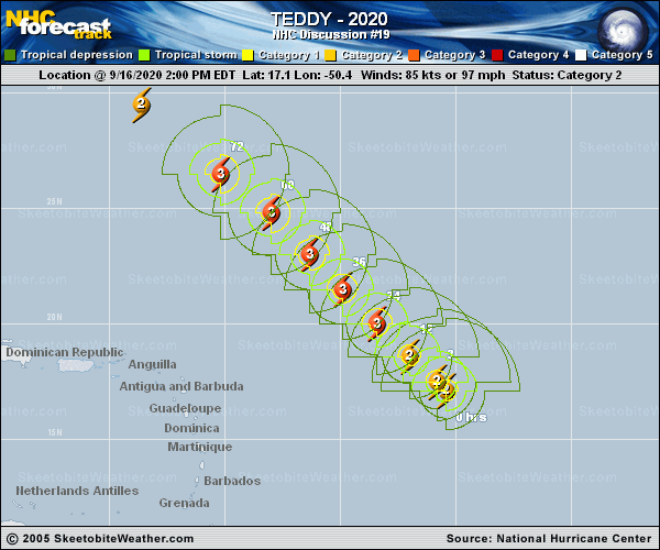
Copy of official data Hurricane Teddy Discussion Number 19 NWS National Hurricane Center Miami FL AL202020 1100 PM AST Wed Sep 16 2020 Teddy has been a perplexing hurricane thus far. The infrared satellite presentation appears rather impressive, with the center embedded beneath a Central Dense Overcast with cloud tops as cold as -85 degrees Celsius. Despite the presentation, however, Dvorak estimates from TAFB and SAB are a consensus T4.5/77 kt, and objective estimates range between 70-75 kt. Teddy's initial intensity is therefore set just above these estimates at 80 kt. A recent ASCAT pass indicated that Teddy's center is a little farther to the southwest than previously estimated. However, the long-term motion remains toward the northwest (315/11 kt). The track forecast remains straightforward the the next 3 days, with the guidance in good agreement that a mid-tropospheric high over the central Atlantic will drive the hurricane northwestward toward the western Atlantic. There is a little more spread among the track models on days 4 and 5, related to timing differences on exactly where and how fast Teddy begins to recurve ahead of an approaching mid-latitude trough coming from the northeastern United States. The new NHC track forecast has been nudged westward during the first 3 days to account for the initial position adjustment, but otherwise it's still close to the previous prediction even with the increasing model spread on days 4 and 5. An upper-level trough situated to the northwest of Teddy is causing about 10-15 kt of deep-layer southwesterly shear over the hurricane, and some model analyses suggest that there could be stronger shear in a layer below the level of the upper-level outflow. The deep-layer shear is expected to increase a bit during the next day or so, but this should be offset by a favorable thermodynamic environment, allowing for some intensification during that time. The shear might relax by days 3 and 4, but then the thermodynamic environment becomes a little less conducive for strengthening. In particular, Teddy may move over the cold wake of Hurricane Paulette, and the SHIPS guidance indicates that relatively warm upper-level temperatures could be a negative factor. All that said, the NHC intensity forecast lies near the top end of the guidance envelope, showing Teddy peaking in intensity in a couple of days and then only gradually weakening through the end of the forecast period. FORECAST POSITIONS AND MAX WINDS INIT 17/0300Z 17.8N 51.5W 80 KT 90 MPH 12H 17/1200Z 18.9N 52.6W 85 KT 100 MPH 24H 18/0000Z 20.3N 54.1W 95 KT 110 MPH 36H 18/1200Z 21.8N 55.6W 100 KT 115 MPH 48H 19/0000Z 23.5N 57.1W 100 KT 115 MPH 60H 19/1200Z 25.3N 59.1W 95 KT 110 MPH 72H 20/0000Z 27.0N 61.1W 95 KT 110 MPH 96H 21/0000Z 30.0N 64.0W 90 KT 105 MPH 120H 22/0000Z 35.0N 64.0W 90 KT 105 MPH $$ Forecaster Berg |