Official Discussion issued by the National Hurricane Center
Sally (AL192020) DATA RELEASED: 9/13/2020 4:00:00 PM UTC
|
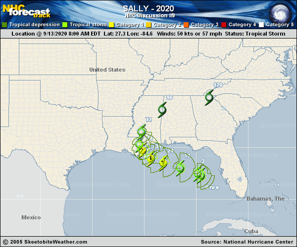
Copy of official data Tropical Storm Sally Discussion Number 9 NWS National Hurricane Center Miami FL AL192020 400 PM CDT Sun Sep 13 2020 The overall structure of Sally has not changed much since this morning, but there has been a recent increase in convection near and to the east of the center this afternoon. It appears that the northwesterly shear is beginning to relax, and the increase in convection near the center may be a harbinger of the expected strengthening phase. Air Force and NOAA Hurricane Hunter aircraft that have been in the storm since the previous advisory have reported a fairly stable central pressure of 996-998 mb, and recent data from the NOAA aircraft still supports an initial intensity of 50 kt. Earlier ASCAT data have been helpful in analyzing the radius of 34-kt winds, which has expand over the eastern semicircle. Sally is forecast to move beneath a narrow upper-level ridge axis through Monday and the expected decrease in shear should allow the storm to strengthen. Since Sally is forecast to decelerate on its approach to the northern Gulf coast, the system still has at least another 36 h to take advantage of the expected conducive environmental conditions. As a result, the NHC intensity forecast continues to call for Sally to become a hurricane on Monday, with additional strengthening likely until landfall. The intensity guidance has trended slightly lower this cycle, with the HMON model now at the upper end of the guidance envelope. The reduction in the statistical guidance is likely due to the fact that Sally has not strengthened today and there is a persistence component to the forecast from those models. The latest NHC intensity forecast is similar to the previous advisory and lies a little above the latest HFIP corrected consensus aid. Recent satellite and aircraft fixes show that Sally continues to move west-northwestward at about 10 kt. The tropical storm is currently being steered around the southern portion of a mid-level ridge to its northeast. Sally is forecast to reach the western extent of the ridge on Monday, and a slower northwestward motion is expected when the storm is near the north-central Gulf coast. The steering currents are forecast to weaken further in a couple of days as Sally rounds the western extent of the ridge and a slow northward motion is expected during that time. By 72 hours, the cyclone should begin to move somewhat faster toward the northeast as a trough deepens to its west. As often occurs, there has been some run-to-run variability among the various track models, and the latest iterations of them have shifted eastward with a slower forward speed. Despite the shifts of the individual models, the latest consensus aids are only slightly north and east of the previous NHC track through 60 hours, so only a small adjustment has been made to the earlier official forecast through that time. It is important not to focus too much on these small track changes and to the exact forecast track itself, as impacts are expected to extend far from the center. Also, since there is still quite a bit of model spread in both the location and timing of when the center of Sally reaches the northern Gulf Coast, additional adjustments to the track forecast are possible. Regardless of Sally's exact landfall location and intensity, the cyclone is expected to bring wind, storm surge, and rainfall hazards to a large part of the north-central Gulf Coast. In particular, Sally's slow forward speed near the coast will exacerbate the storm surge and heavy rainfall threats. KEY MESSAGES: 1. An extremely dangerous and life-threatening storm surge is expected for areas outside the southeastern Louisiana Hurricane and Storm Damage Risk Reduction System from Port Fourchon, Louisiana, to the Mississippi/Alabama border, where a Storm Surge Warning is in effect. Residents in these areas should follow any advice given by local officials. 2. Hurricane conditions are expected by late Monday within portions of the Hurricane Warning area from Morgan City, Louisiana, to Ocean Springs, Mississippi, including Metropolitan New Orleans, with tropical storm conditions likely to begin Monday. Preparations should be rushed to completion in those areas. 3. Sally could continue to produce flash flooding across central and northern Florida and prolong existing minor river flooding across west-central Florida through Monday. Widespread significant flash flooding and minor to isolated major river flooding is likely across southeastern Louisiana, Mississippi, and Alabama through the middle of the week. Flooding impacts are expected to spread farther across the Southeast U.S. through the week. FORECAST POSITIONS AND MAX WINDS INIT 13/2100Z 27.8N 85.9W 50 KT 60 MPH 12H 14/0600Z 28.3N 87.3W 60 KT 70 MPH 24H 14/1800Z 28.7N 88.7W 70 KT 80 MPH 36H 15/0600Z 29.2N 89.6W 80 KT 90 MPH 48H 15/1800Z 29.8N 90.1W 60 KT 70 MPH...INLAND 60H 16/0600Z 30.7N 90.1W 45 KT 50 MPH...INLAND 72H 16/1800Z 31.8N 89.6W 30 KT 35 MPH...INLAND 96H 17/1800Z 33.5N 87.5W 25 KT 30 MPH...INLAND 120H 18/1800Z 34.5N 83.0W 20 KT 25 MPH...POST-TROP/REMNT LOW $$ Forecaster Brown |