Official Discussion issued by the National Hurricane Center
Sally (AL192020) DATA RELEASED: 9/15/2020 4:00:00 PM UTC
|
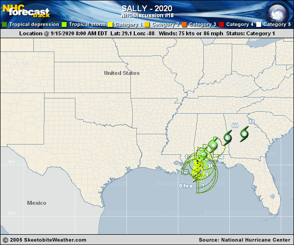
Copy of official data Hurricane Sally Discussion Number 18 NWS National Hurricane Center Miami FL AL192020 400 PM CDT Tue Sep 15 2020 Sally has been inching its way toward the north-central Gulf Coast today. The overall structure of the storm has remained about the same during the day with a large ragged eye in apparent in radar imagery. A NOAA P-3 aircraft that has been sampling the storm since late this morning has reported peak flight-level winds of 76 kt, and NWS Doppler radar has shown velocities of 75-80 kt at around 7000 ft. The intensity was reduced to 70 kt on the 1800 UTC intermediate advisory and remains at that value for this advisory. Radar and aircraft fixes show that Sally has been moving very slowly toward the north or 350/2 kt. The track forecast philosophy remains unchanged from the previous advisory. Sally is currently located within an area of weak steering flow between a couple of mid-level ridges to its east and west. A weak mid-level trough over the south-central United States is forecast to slide eastward over the next few days, which should cause Sally to turn north-northeastward and then northeastward over the next 24-36 hours. Sally's forward speed is expected to remain quite slow over the next 24-48 hours, but the guidance has trended slightly faster after that time. The slow forward speed is likely to result in a historical rainfall event for the north-central Gulf Coast. It may sound like a broken record, but the track guidance has again shifted eastward during the first 24-36 hours, and the NHC forecast has been adjusted accordingly. Since Sally has a large wind field, and storm surge and rainfall hazards extend far from the eye, users should not focus on the exact forecast track or specific location and timing of landfall as strong winds and bands of heavy rainfall are already affecting the Gulf Coast and will continue to do so for quite some time. The combination of upwelling and moderate westerly shear is likely to result in little change in strength prior to Sally moving onshore. Once the center of the hurricane moves onshore, rapid weakening is expected and the global models indicate that the circulation will becoming elongated along a frontal boundary in 3 to 4 days. KEY MESSAGES: 1. Historic life-threatening flash flooding due to rainfall is likely through Wednesday along and just inland of the coast from the Florida Panhandle west of the Apalachicola River to far southeastern Mississippi. Widespread moderate to major river flooding is forecast along and just inland of the central Gulf Coast. Significant flash and urban flooding, as well as widespread minor to moderate river flooding, is likely across inland portions of Mississippi and Alabama, and into Georgia and the western Carolinas this week. 2. Life-threatening storm surge is expected along portions of the coastline from Alabama to the western Florida Panhandle, including Mobile Bay. 3. Hurricane conditions are expected this evening and overnight within portions of the Hurricane Warning area along the Mississippi and Alabama coastlines and the western Florida Panhandle. FORECAST POSITIONS AND MAX WINDS INIT 15/2100Z 29.5N 88.1W 70 KT 80 MPH 12H 16/0600Z 29.9N 88.1W 70 KT 80 MPH 24H 16/1800Z 30.6N 87.7W 60 KT 70 MPH...INLAND 36H 17/0600Z 31.5N 86.9W 40 KT 45 MPH...INLAND 48H 17/1800Z 32.5N 85.3W 30 KT 35 MPH...INLAND 60H 18/0600Z 33.1N 83.3W 25 KT 30 MPH...INLAND 72H 18/1800Z 33.5N 81.0W 20 KT 25 MPH...POST-TROP/REMNT LOW 96H 19/1800Z...DISSIPATED $$ Forecaster Brown |