Official Discussion issued by the National Hurricane Center
Sally (AL192020) DATA RELEASED: 9/15/2020 4:00:00 AM UTC
|
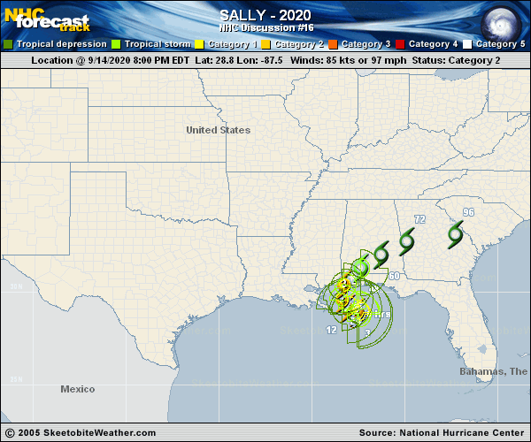
Copy of official data Hurricane Sally Discussion Number 16 NWS National Hurricane Center Miami FL AL192020 400 AM CDT Tue Sep 15 2020 There has been little change overall in Sally's convective structure in both satellite and Doppler radar data. An eye has tried to close off several times this morning, but after less than 30 minutes the southern eyewall has eroded. Until just recently, the central pressure had been steady for the past several hours at 986 mb. However, the most recent Air Force Reserve reconnaissance pass through Sally's center reported a dropsonde pressure of 984 mb and 13 kt winds, which equals a pressure of 983 mb. Maximum 700-mb flight-level winds observed have only been 63 kt and peak SFMR winds have been 58 kt. Also, reports from nearby oil rigs have dropped off significantly since yesterday are are now in the 40-50 kt range. Based on these data, the initial intensity has been lowered to 75 kt. The initial motion estimate to 300/02 kt. After a brief jog due west, it appears that Sally ahs resumed a slow drift toward the west-northwest. Sally is embedded within weak steering flow based on 0000Z upper-air data indicating 500-mb heights of 5900 meters and slightly higher surrounding the cyclone from Florida northward into the Tennessee Valley and then westward into the central and southern Plains. This weak steering pattern is expected to persist for the next few days, with a weak mid-level trough expected to move into the Missouri and Tennessee Valleys by Wednesday and Thursday, which will gradually lift Sally northward and then northeastward. Sally is forecast to merge with a frontal system by day 4 or 5. The new NHC forecast track is similar to the previous advisory and lies down the middle of the rather divergent model guidance envelope. Sally is now expected to remain in a moderate to high mid-to upper-level wind shear environment. Ina addition, some modest upwelling is likely occurring in the inner-core region based a SST decrease of nearly 2 deg F during the past 24 hours based on data from buoy 42012. After the Sally makes landfall, rapid weakening is forecast and Sally should become post-tropical in 3 days or less. Users are reminded to not focus on the exact forecast track or the specific timing and location of landfall. Hurricane-force winds, dangerous storm surge, and flooding rainfall will affect a large portion of the north-central Gulf Coast during the next few days. KEY MESSAGES: 1. It is still too early to determine where Sally's center will move onshore given the uncertainty in the timing and location of Sally's northward turn near the central Gulf Coast. Users should not focus on the details of the official forecast track, since NHC's average forecast error at 36 hours is around 60 miles, and dangerous storm surge, rainfall, and wind hazards will extend well away from the center. 2. An extremely dangerous and life-threatening storm surge is expected for areas outside the southeastern Louisiana Hurricane and Storm Damage Risk Reduction System from Port Fourchon, Louisiana, to the Okaloosa/Walton County Line in the Florida Panhandle, where a Storm Surge Warning is in effect. Residents in these areas should follow any advice given by local officials. 3. Hurricane conditions are expected early Tuesday within the Hurricane Warning area in southeastern Louisiana and are expected by late Tuesday and Tuesday night within the Hurricane Warning area along the Mississippi and Alabama coastlines and the western Florida Panhandle. Tropical storm conditions are already occurring in some of these areas. 4. Historic flooding is possible with extreme life-threatening flash flooding likely through Wednesday along and just inland of the central Gulf Coast from the western Florida Panhandle to far southeastern Mississippi. Widespread moderate to major flooding on area rivers is forecast along and just inland of the central Gulf Coast. Significant flash and urban flooding, as well as widespread minor to moderate river flooding is likely across inland portions of Mississippi, Alabama, northern Georgia, and the western Carolinas through the week. FORECAST POSITIONS AND MAX WINDS INIT 15/0900Z 28.9N 88.1W 80 KT 90 MPH 12H 15/1800Z 29.2N 88.4W 75 KT 85 MPH 24H 16/0600Z 29.9N 88.5W 75 KT 85 MPH 36H 16/1800Z 30.6N 88.3W 60 KT 70 MPH...INLAND 48H 17/0600Z 31.4N 87.5W 35 KT 40 MPH...INLAND 60H 17/1800Z 32.2N 86.2W 25 KT 30 MPH...INLAND 72H 18/0600Z 32.8N 84.6W 20 KT 25 MPH...POST-TROP/REMNT LOW 96H 19/0600Z 33.2N 81.3W 20 KT 25 MPH...POST-TROP/EXTRATROP 120H 20/0600Z...DISSIPATED $$ Forecaster Stewart |