Official Discussion issued by the National Hurricane Center
Sally (AL192020) DATA RELEASED: 9/14/2020 4:00:00 AM UTC
|
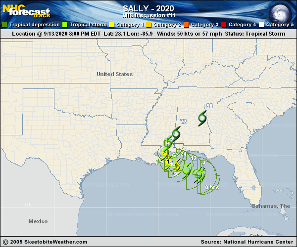
Copy of official data Tropical Storm Sally Discussion Number 11 NWS National Hurricane Center Miami FL AL192020 400 AM CDT Mon Sep 14 2020 The organization of Sally hasn't changed much during the past several hours. While there was a large burst of convection earlier, it did not translate into any intensification, with flight-level reconnaissance and SFMR surface winds still supporting an initial wind speed of 50 kt. The Air Force Reserve plane did find that the size of tropical-storm-force wind field has notable grown to the north and northwest of the center. The storm still has time to intensify under a seemingly conducive environment during the next 24-36 hours, before a combination of increasing westerly wind shear and land interaction will probably slow the intensification rate. Model guidance has come down slightly from 6 hours ago, but it has been inconsistent from cycle to cycle. The new intensity forecast is similar to the previous one and lies near the top end of the guidance envelope. The reconnaissance plane showed that Sally took a westward turn during the past several hours, but the storm appears to have a resumed a more west-northwestward motion recently. Weak ridging over the southern United States is expected to cause this general motion with a decrease in forward speed today before the storm slowly turns northward sometime on Tuesday due to an approaching trough. Guidance is not in good agreement on exactly when that turn occurs, causing a good deal of spread for a relatively short-range forecast. The track forecast has been shifted to the left in the short-term primarily due to the initial position, showing a track near or over extreme southeastern Louisiana, then is the near the previous one at its final landfall. The bottom line continues to be that Sally is expected to be a dangerous slow-moving hurricane near the coast of southeastern Louisiana, Mississippi and Alabama during the next 2-3 days. KEY MESSAGES: 1. It is too early to determine where Sally's center will move onshore given the uncertainty in the timing and location of Sally's northward turn near the central Gulf Coast. Users should not focus on the details of the official forecast track, since NHC's average forecast error at 48 hours is around 80 miles, and dangerous storm surge, rainfall, and wind hazards will extend well away from the center. 2. An extremely dangerous and life-threatening storm surge is expected for areas outside the southeastern Louisiana Hurricane and Storm Damage Risk Reduction System from Port Fourchon, Louisiana, to the Alabama/Florida border, where a Storm Surge Warning is in effect. Residents in these areas should follow any advice given by local officials. 3. Hurricane conditions are expected by late today within portions of the Hurricane Warning area from Morgan City, Louisiana, to the Mississippi/Alabama border, including Metropolitan New Orleans, with tropical storm conditions likely to begin by late this morning. Preparations should be rushed to completion in those areas. 4. Sally could continue to produce flash flooding across central and northern Florida and prolong existing minor river flooding across west-central Florida through today. Widespread significant flash flooding and minor to isolated major river flooding is likely across southeastern Louisiana, Mississippi, and Alabama through the middle of the week. Flooding impacts are expected to spread farther across the Southeast U.S. through the week. FORECAST POSITIONS AND MAX WINDS INIT 14/0900Z 28.3N 87.3W 50 KT 60 MPH 12H 14/1800Z 28.6N 88.1W 60 KT 70 MPH 24H 15/0600Z 29.1N 88.9W 70 KT 80 MPH 36H 15/1800Z 29.7N 89.3W 75 KT 85 MPH 48H 16/0600Z 30.6N 89.2W 60 KT 70 MPH...INLAND 60H 16/1800Z 31.6N 88.6W 30 KT 35 MPH...INLAND 72H 17/0600Z 32.5N 87.6W 25 KT 30 MPH...INLAND 96H 18/0600Z 33.5N 85.0W 20 KT 25 MPH...POST-TROP/REMNT LOW 120H 19/0600Z...DISSIPATED $$ Forecaster Blake |