Official Discussion issued by the National Hurricane Center
Rene (AL182020) DATA RELEASED: 9/8/2020 2:00:00 PM UTC
|
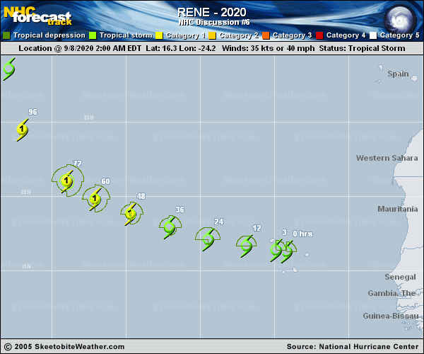
Copy of official data Tropical Storm Rene Discussion Number 6 NWS National Hurricane Center Miami FL AL182020 200 PM CVT Tue Sep 08 2020 Rene is starting to pull away from the Cabo Verde Islands, though some of the outer rainbands are affecting the far northwestern islands. Although the tropical storm has a well-defined circulation, the convective banding features have not become any better organized since yesterday. The satellite classifications are largely unchanged and range from 25 to 37 kt, and a recent ASCAT-B pass showed maximum winds in the 30-35 kt range. Based on all of this data, the initial intensity is again held at 35 kt. The tropical storm is moving westward at a faster pace of 14 kt. A mid-level ridge to the north of Rene is expected to build westward, which should cause the cyclone to move westward to west-northwestward at about the same forward speed during the next couple of days. After that time, the storm is expected to slow down and turn northwestward and then northward as it moves into a pronounced weakness in the ridge. Although the models agree on the overall scenario, there are notable differences in where and how sharply Rene will recurve with the GFS on the right side of the guidance and the ECMWF on the left. The NHC track forecast is adjusted a little to the right of the previous one, but still lies closer to the left side of the guidance envelope between the HCCA and TVCA consensus aids. Although Rene has not strengthened since yesterday, the models continue to suggest that the storm will steadily strengthen during the next few days while it moves over relatively warm 26-27 C waters and remains in environment of low wind shear and high moisture. Beyond that time, increasing southwesterly wind shear and drier air should end the strengthening trend and induce gradual weakening. The NHC intensity forecast is largely an update of the previous one and lies near the HCCA and IVCN models. Key Messages: 1. Rene is expected to produce tropical storm conditions across portions of the western Cabo Verde Islands for a few more hours. A Tropical Storm Warning remains in effect for those islands. 2. Rene will continue to bring locally heavy rainfall to portions of the western Cabo Verde Islands today. FORECAST POSITIONS AND MAX WINDS INIT 08/1500Z 16.5N 26.5W 35 KT 40 MPH 12H 09/0000Z 16.8N 28.5W 35 KT 40 MPH 24H 09/1200Z 17.4N 31.1W 45 KT 50 MPH 36H 10/0000Z 18.3N 33.7W 55 KT 65 MPH 48H 10/1200Z 19.3N 36.2W 65 KT 75 MPH 60H 11/0000Z 20.5N 38.2W 70 KT 80 MPH 72H 11/1200Z 22.1N 39.8W 70 KT 80 MPH 96H 12/1200Z 26.5N 42.2W 60 KT 70 MPH 120H 13/1200Z 29.7N 42.0W 50 KT 60 MPH $$ Forecaster Cangialosi |