Official Discussion issued by the National Hurricane Center
Rene (AL182020) DATA RELEASED: 9/8/2020 8:00:00 AM UTC
|
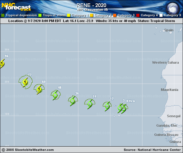
Copy of official data Tropical Storm Rene Discussion Number 5 NWS National Hurricane Center Miami FL AL182020 800 AM CVT Tue Sep 08 2020 While Rene continues to have a well-defined circulation, satellite imagery indicates that the associated convection remains poorly organized. Various subjective and objective satellite intensity estimates are in the 30-35 kt range. Based on these, along with a 28 kt observation from Sal/GVAC, the initial intensity remains a possible generous 35 kt. The initial motion is westward or 280/13 kt. There is no change in the track forecast philosophy, as a westward motion is expected today, followed by a west-northwestward motion through Thursday as Rene rounds the southwestern periphery of a deep-layer subtropical ridge. On days 4 and 5, the cyclone is forecast to move more slowly northwestward to north-northwestward through a weakness in the aforementioned ridge. The track guidance has shifted a little eastward after 72 h, and the new track forecast is also nudged eastward during that time. Other than that, the new forecast track is similar to the previous track. It is unclear why the convection is currently so poorly organized, although land interaction with the Cabo Verde Islands is a possibility. Conditions generally appear favorable for strengthening during the next three days or so, and much of the intensity guidance forecasts Rene to become a hurricane in 2-3 days time even though the water temperatures gradually decrease along the forecast track. After 72 h, Rene is expected to reach both warmer water and strong westerly shear, with the latter expected to cause the storm to weaken. The new intensity forecast has only minor tweaks from the previous forecast and follows the trend of the intensity guidance. Key Messages: 1. Rene is expected to produce tropical storm conditions across portions of the Cabo Verde Islands today. A Tropical Storm Warning is in effect for those islands. 2. Rene will bring locally heavy rainfall to portions of the Cabo Verde Islands today. FORECAST POSITIONS AND MAX WINDS INIT 08/0900Z 16.4N 24.9W 35 KT 40 MPH 12H 08/1800Z 16.7N 26.9W 35 KT 40 MPH 24H 09/0600Z 17.1N 29.5W 45 KT 50 MPH 36H 09/1800Z 17.9N 32.1W 55 KT 65 MPH 48H 10/0600Z 18.8N 34.7W 65 KT 75 MPH 60H 10/1800Z 19.8N 37.1W 70 KT 80 MPH 72H 11/0600Z 21.0N 39.0W 70 KT 80 MPH 96H 12/0600Z 24.5N 42.0W 65 KT 75 MPH 120H 13/0600Z 28.6N 42.9W 55 KT 65 MPH $$ Forecaster Beven |