Official Discussion issued by the National Hurricane Center
Rene (AL182020) DATA RELEASED: 9/14/2020 3:00:00 AM UTC
|
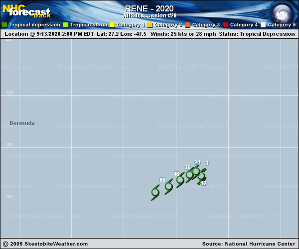
Copy of official data Tropical Depression Rene Discussion Number 28 NWS National Hurricane Center Miami FL AL182020 1100 PM AST Sun Sep 13 2020 Rene continues to produced puffs of deep convection that are continually being sheared away by nearly 30 kt of westerly shear. These brief convective bursts have not been sufficiently organized to warrant a Dvorak classification for about 12 hours, so if the convective organization does not increase soon, Rene could become a remnant low tonight. Continued shear and a very dry mid-level environment should result in Rene's remnants dissipating by 60 hours, if not sooner. Rene's forward speed has slowed since the last advisory, with a westward drift of 270/02 the current estimate. The shallow cyclone should accelerate west-southwestward or southwestward in the low-level flow by 24 hours and continue on that general motion until dissipation. The new NHC track forecast is adjusted south of the previous one toward the new multi-model consensus. FORECAST POSITIONS AND MAX WINDS INIT 14/0300Z 27.2N 47.9W 25 KT 30 MPH 12H 14/1200Z 27.3N 48.3W 25 KT 30 MPH...POST-TROP/REMNT LOW 24H 15/0000Z 26.9N 49.1W 20 KT 25 MPH...POST-TROP/REMNT LOW 36H 15/1200Z 26.2N 50.2W 20 KT 25 MPH...POST-TROP/REMNT LOW 48H 16/0000Z 25.5N 51.4W 20 KT 25 MPH...POST-TROP/REMNT LOW 60H 16/1200Z...DISSIPATED $$ Forecaster Brennan |