Official Discussion issued by the National Hurricane Center
Eighteen (AL182020) DATA RELEASED: 9/7/2020 2:00:00 PM UTC
|
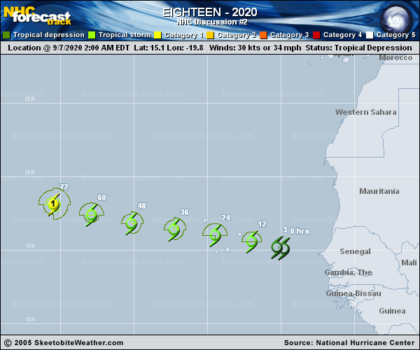
Copy of official data Tropical Depression Eighteen Discussion Number 2 NWS National Hurricane Center Miami FL AL182020 200 PM CVT Mon Sep 07 2020 Tropical Depression Eighteen is very near tropical storm strength. Satellite images show banding features gradually organizing on the west side of the circulation. An ASCAT-B overpass showed maximum winds around or slightly above 30 kt in the bands to the northwest of the center. The Dvorak classifications from TAFB and SAB are lower, however. The initial intensity is held at 30 kt for now, but it seems very likely that the depression will become a tropical storm later today. The cyclone is moving west-northwestward at 9 kt. A subtropical ridge situated to the north of the system is expected to build westward across the eastern Atlantic during the next 3 or 4 days. This steering pattern should keep the system on a general west-northwestward course during that time. By the weekend, the depression will likely be moving into a weakness in the ridge, which should cause a turn to the northwest. The models are in good agreement during the next few days, but there is increasing spread in the guidance by the end of the forecast period. The NHC forecast is very similar to the previous one and lies near the various consensus models. The depression will likely strengthen during the next few days as it remains in conducive environmental conditions of low wind shear, relatively warm waters, and a moist airmass. There will likely be an increase in shear by the end of the week and this weekend, which should end the strengthening trend and perhaps induce some weakening at that time. The NHC intensity forecast is largely an update of the previous one, and lies near the high end of the model guidance. Key Messages: 1. The depression is forecast to strengthen into a tropical storm later today and tropical storm conditions are expected to spread over portions of the Cabo Verde Islands later today and tonight. A Tropical Storm Warning is in effect for those islands. 2. The depression is expected to bring locally heavy rainfall to portions of the Cabo Verde Islands through Tuesday morning. FORECAST POSITIONS AND MAX WINDS INIT 07/1500Z 15.7N 21.2W 30 KT 35 MPH 12H 08/0000Z 16.1N 23.1W 35 KT 40 MPH 24H 08/1200Z 16.5N 25.8W 45 KT 50 MPH 36H 09/0000Z 16.9N 28.6W 50 KT 60 MPH 48H 09/1200Z 17.4N 31.5W 55 KT 65 MPH 60H 10/0000Z 18.0N 34.1W 60 KT 70 MPH 72H 10/1200Z 18.6N 36.5W 65 KT 75 MPH 96H 11/1200Z 20.6N 40.6W 70 KT 80 MPH 120H 12/1200Z 23.2N 43.8W 65 KT 75 MPH $$ Forecaster Cangialosi |