Official Discussion issued by the National Hurricane Center
Rene (AL182020) DATA RELEASED: 9/11/2020 3:00:00 PM UTC
|
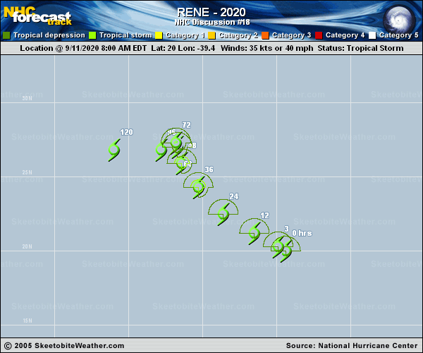
Copy of official data Tropical Storm Rene Discussion Number 18 NWS National Hurricane Center Miami FL AL182020 1100 AM AST Fri Sep 11 2020 Rene lost essentially all of its deep convection over the past several hours, however recently some new thunderstorms have developed over the western part of the circulation. The cause of the system's decline is not clear. One negative environmental factor could be dry air, since the SHIPS output based on the GFS model shows mid-level relative humidities of 50-55 percent. Using a blend of Dvorak current intensity estimates from TAFB and SAB along with objective ADT values from UW-CIMSS gives a rather uncertain advisory intensity of 35 kt. Since the cyclone should remain over waters of 26.5 deg C or warmer and the shear is not expected to increase much during the next day or two, some re-intensification is expected. Based on the current state of Rene, the official intensity forecast is revised downward to show less strengthening through 48 hr compared to the previous predictions. By the latter part of the forecast period, increasing northwesterly shear should result in weakening. The NHC forecast is above most of the intensity guidance. The latest center fixes give a slightly faster west-northwestward motion of 290/11 kt. Rene should continue to move around the western periphery of a mid-level anticyclone for the next couple of days. Then, a high pressure area building to the north and northwest of the cyclone should induce a slowing of the forward speed and a turn toward the left. The official track forecast is similar to the previous one and closely aligned with the NOAA corrected consensus, HCCA, prediction. FORECAST POSITIONS AND MAX WINDS INIT 11/1500Z 20.3N 39.9W 35 KT 40 MPH 12H 12/0000Z 21.2N 41.5W 40 KT 45 MPH 24H 12/1200Z 22.5N 43.6W 45 KT 50 MPH 36H 13/0000Z 24.3N 45.3W 50 KT 60 MPH 48H 13/1200Z 25.9N 46.4W 50 KT 60 MPH 60H 14/0000Z 27.0N 46.7W 45 KT 50 MPH 72H 14/1200Z 27.3N 46.8W 45 KT 50 MPH 96H 15/1200Z 26.8N 47.8W 40 KT 45 MPH 120H 16/1200Z 26.8N 51.0W 35 KT 40 MPH $$ Forecaster Pasch |