Official Discussion issued by the National Hurricane Center
Rene (AL182020) DATA RELEASED: 9/11/2020 3:00:00 AM UTC
|
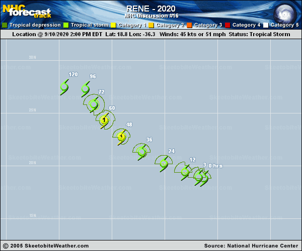
Copy of official data Tropical Storm Rene Discussion Number 16 NWS National Hurricane Center Miami FL AL182020 1100 PM AST Thu Sep 10 2020 Microwave satellite images from late this afternoon and evening shows that the center of Rene is located slightly northeast of the main convective mass. This appears to be due to some easterly flow that is undercutting the outflow layer. Dvorak CI numbers from both SAB and TAFB remain 3.0 (45 kt) but the SAB T-number has decreased slightly, and a recent ASCAT overpass suggests that the winds are not as strong as previously estimated. The ASCAT data revealed peak winds of 30-35 kt, so the initial intensity has been adjusted to 40 kt, which could be a little generous. The upper-level wind pattern is expected to become favorable for strengthening while the cyclone moves over marginally warm sea surface temperatures during the next day or two. This should allow for some modest strengthening during that time, but the statistical guidance is not as bullish as before. Therefore the intensity forecast has been lowered slightly, and if strengthening does not occur soon additional downward adjustments to the intensity prediction may be needed. By 60 h, Rene is forecast to move into an area of strong west-northwesterly shear, which is expected to weaken the cyclone during the latter portion of the forecast period. Rene continues moving west-northwestward with a motion of 290/10 kt. The cyclone is approaching the western periphery of a mid-level ridge over the eastern Atlantic and Rene is forecast to turn northwestward and then north-northwestward over the next few days. Later in the period, a ridge is forecast to build to the northwest of the tropical cyclone and Rene's forward motion is expected to slow considerably early next week. There is a fair amount of model spread by 96 and 120 h, with some of the global models taking Rene more northeastward during that time. The NHC forecast continues to lie close to the various consensus aids, and indicates a fairly slow forward speed on days 3-5. FORECAST POSITIONS AND MAX WINDS INIT 11/0300Z 19.3N 37.6W 40 KT 45 MPH 12H 11/1200Z 19.8N 39.1W 45 KT 50 MPH 24H 12/0000Z 20.7N 41.1W 50 KT 60 MPH 36H 12/1200Z 22.0N 43.1W 55 KT 65 MPH 48H 13/0000Z 23.7N 44.9W 60 KT 70 MPH 60H 13/1200Z 25.2N 46.1W 60 KT 70 MPH 72H 14/0000Z 26.4N 46.9W 55 KT 65 MPH 96H 15/0000Z 27.3N 47.5W 45 KT 50 MPH 120H 16/0000Z 27.5N 49.7W 40 KT 45 MPH $$ Forecaster Brown |