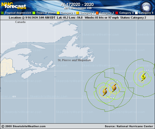
Official Discussion issued by the National Hurricane Center
(AL172020) DATA RELEASED: 9/16/2020 3:00:00 PM UTC
|
Copy of official data Post-Tropical Cyclone Paulette Discussion Number 39 NWS National Hurricane Center Miami FL AL172020 1100 AM AST Wed Sep 16 2020 Conventional GOES-16 visible and enhanced BD-curve satellite imagery show that Paulette has merged with the large baroclinic zone extending over the north-central Atlantic. Deep convection just to the north of the surface center that was noted on earlier microwave images has dissipated. Therefore, the system is now classified as extratropical cyclone and this is the last NHC advisory. The initial intensity is conservatively lowered to 75 kt based on 1221 UTC scatterometer data, earlier Dvorak intensity estimates and a SATCON analysis of 64 kt. The NHC intensity forecast is based on a blend of the global models and is just above the HCCA multi-model consensus. Although not specified in the NHC forecast, there is some chance that Paulette could reacquire tropical or subtropical characteristics later this week or over the weekend when it turns southward back over warmer oceanic temperatures. This possibility will be monitored for inclusion in future Tropical Weather Outlooks, if necessary. The post-tropical cyclone's initial motion is east-northeastward, or 060/30 kt. The low is expected to continue quickly in this general motion through Thursday morning within the deep-layer mid-latitude flow. By mid-period, Post-Tropical Paulette is expected to slow down and turn southeastward to southward as it moves on the west side of mid- to upper-level low to the east of the cyclone. The new track forecast is based primarily on the HCCA and TVCA consensus aids. Paulette is producing a large area of high seas. The maximum seas estimated by the Ocean Prediction Center near the core of the hurricane are up to 50 feet. Swells from Post-Tropical Cyclone Paulette have spread far away from the center and continue to affect Atlantic Canada, Bermuda, and portions of the U.S. east coast. This is the last NHC advisory on Paulette. Additional information on this system can be found in High Seas Forecasts issued by the National Weather Service, under AWIPS header NFDHSFAT1, WMO header FZNT01 KWBC, and online at ocean.weather.gov/shtml/NFDHSFAT1.php FORECAST POSITIONS AND MAX WINDS INIT 16/1500Z 43.3N 45.2W 75 KT 85 MPH...POST-TROP/EXTRATROP 12H 17/0000Z 45.0N 39.9W 60 KT 70 MPH...POST-TROP/EXTRATROP 24H 17/1200Z 46.2N 35.3W 50 KT 60 MPH...POST-TROP/EXTRATROP 36H 18/0000Z 45.1N 33.1W 40 KT 45 MPH...POST-TROP/EXTRATROP 48H 18/1200Z 42.5N 32.5W 35 KT 40 MPH...POST-TROP/EXTRATROP 60H 19/0000Z 39.5N 32.5W 35 KT 40 MPH...POST-TROP/EXTRATROP 72H 19/1200Z 37.0N 32.7W 35 KT 40 MPH...POST-TROP/EXTRATROP 96H 20/1200Z 35.0N 32.9W 35 KT 40 MPH...POST-TROP/EXTRATROP 120H 21/1200Z 34.0N 32.4W 35 KT 40 MPH...POST-TROP/EXTRATROP $$ Forecaster Roberts |