Official Discussion issued by the National Hurricane Center
Paulette (AL172020) DATA RELEASED: 9/14/2020 9:00:00 AM UTC
|
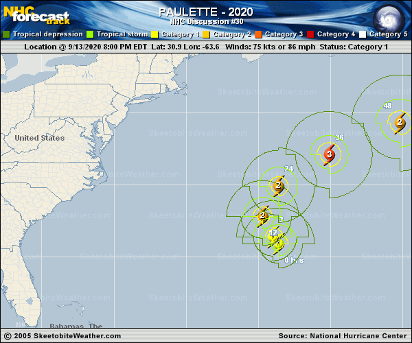
Copy of official data Hurricane Paulette Discussion Number 30 NWS National Hurricane Center Miami FL AL172020 500 AM AST Mon Sep 14 2020 The large, 35-40-mile-wide eye of Paulette is located over northeastern Bermuda, and nearly the entire island is inside the eye. The last Air Force Reserve hurricane hunter mission measured peak 700-mb flight-level winds of 88 kt in the northeastern quadrant where data from satellites and the Bermuda radar (the radar is still functioning) indicate a large burst of deep convection has developed and persisted in that part of the eyewall, likely bringing down much of those winds to the surface. Using a standard 90-percent adjustment factor yields a surface wind estimate near 80 kt, and that is the intensity used for this advisory. The last reported pressure by the aircraft was 973 mb, which has been confirmed by surface observations from Bermuda. The initial motion estimate is 345/10 kt. The track, intensity, and wind radii forecasts remain essentially unchanged since all of the latest NHC guidance appears to be tightly dialed in on Paulette's future. Additional strengthening appears likely after Paulette moves away from Bermuda and accelerates northeastward over the North Atlantic. Paulette is expected to be at or near major hurricane strength on Tuesday. By the end of the forecast period, weakening is forecast as Paulette interacts with a mid-latitude trough and begins to lose its tropical characteristics. The NHC intensity forecast is remains just above the intensity consensus, but is within the tightly clustered guidance envelope at all times. Confidence in the track forecast also remains high, and the latest track guidance is tightly packed about the previous advisory track. Paulette will move northward away from Bermuda today, followed by a turn toward the northeast by tonight and on Tuesday. A slower eastward to southeastward motion is expected by Friday when a large mid-tropospheric cut-off low over the eastern Atlantic is forecast to begin influencing Paulette's track. Key Messages: 1. The eye of Paulette will gradually move away from Bermuda this morning, with hurricane conditions returning within a couple of hours. A prolonged period of strong winds, storm surge, and very heavy rainfall will likely continue into this afternoon. 2. Swells produced by Paulette are affecting portions of the Leeward Islands, the Greater Antilles, the Bahamas, Bermuda, and the east coast of the United States. These swells could cause life-threatening surf and rip current conditions. FORECAST POSITIONS AND MAX WINDS INIT 14/0900Z 32.3N 64.7W 80 KT 90 MPH 12H 14/1800Z 33.9N 64.4W 85 KT 100 MPH 24H 15/0600Z 36.1N 62.1W 95 KT 110 MPH 36H 15/1800Z 38.4N 57.6W 100 KT 115 MPH 48H 16/0600Z 40.9N 51.8W 95 KT 110 MPH 60H 16/1800Z 43.4N 45.3W 85 KT 100 MPH 72H 17/0600Z 45.3N 40.0W 75 KT 85 MPH 96H 18/0600Z 45.5N 36.3W 55 KT 65 MPH 120H 19/0600Z 41.6N 34.0W 45 KT 50 MPH...POST-TROP/EXTRATROP $$ Forecaster Stewart |