Official Discussion issued by the National Hurricane Center
Paulette (AL172020) DATA RELEASED: 9/7/2020 3:00:00 PM UTC
|
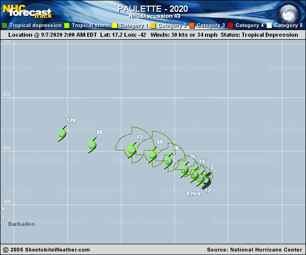
Copy of official data Tropical Storm Paulette Discussion Number 3 NWS National Hurricane Center Miami FL AL172020 1100 AM AST Mon Sep 07 2020 Visible imagery and recent ASCAT data indicate that the circulation of Paulette is quite elongated from southwest to northeast. However, the ASCAT data indicated that winds up to tropical-storm-force were present, and this was corroborated by a 35 kt Dvorak-based intensity estimate from TAFB. Paulette is the 16th named storm of the 2020 Atlantic hurricane season. It is also the earliest 16th named storm of any Atlantic season by 10 days. The previous record was Philippe, which formed on September 17, 2005. Although it is elongated, the tropical storm's structure seems to have improved over the past few hours, with convection increasing in both coverage and organization. Although moderate southerly shear and some dry environmental air appear to be limiting factors, most of the intensity guidance suggests that modest strengthening is likely for the next couple of days. Near the end of the week, the models indicate that Paulette's winds will plateau or possibly decrease. This appears to be the result of increasing southwesterly shear associated with a upper-level trough that is forecast to deepen over the central Atlantic on Thursday and Friday. The official intensity forecast remains very near the multi-model consensus. Paulette has moved very little during the past few hours, but a west-northwestward to northwestward motion is expected to resume shortly. Fluctuations in the strength of a mid-level ridge over the western and central Atlantic will likely cause Paulette's exact speed and heading to fluctuate during the next several says, but the guidance agrees that it should generally head northwestward through the end of the week. It is likely that the stronger Paulette gets, the farther north it will move since the aforementioned upper-level trough will have a greater influence on its track. The NHC track forecast is based on a blend of the previous forecast and the latest multi-model consensus. FORECAST POSITIONS AND MAX WINDS INIT 07/1500Z 17.2N 42.2W 35 KT 40 MPH 12H 08/0000Z 17.4N 42.5W 40 KT 45 MPH 24H 08/1200Z 17.9N 43.2W 40 KT 45 MPH 36H 09/0000Z 18.7N 44.4W 45 KT 50 MPH 48H 09/1200Z 19.6N 46.0W 50 KT 60 MPH 60H 10/0000Z 20.3N 48.2W 50 KT 60 MPH 72H 10/1200Z 20.7N 50.0W 50 KT 60 MPH 96H 11/1200Z 21.0N 53.0W 45 KT 50 MPH 120H 12/1200Z 23.0N 56.5W 45 KT 50 MPH $$ Forecaster Zelinsky |