Official Discussion issued by the National Hurricane Center
Paulette (AL172020) DATA RELEASED: 9/12/2020 9:00:00 PM UTC
|
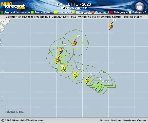
Copy of official data Tropical Storm Paulette Discussion Number 24 NWS National Hurricane Center Miami FL AL172020 500 PM AST Sat Sep 12 2020 Convective cloud tops have cooled again as deep convection has redeveloped since this morning, with an eye-like feature noted in visible satellite imagery. Since the storm is still being affected by 20-25 kt of southerly shear, it is assumed that the low-level center is still displaced to the south of this feature a bit. But it won't be surprising if the low- and mid-level centers become collocated soon as the shear drops significantly during the next 6-12 hours. The initial intensity remains 60 kt, and we should get a much better handle on Paulette's maximum winds and structure once the first Air Force Hurricane Hunter aircraft reaches the storm this evening. The motion remains northwestward (305/13 kt) due to a break in the subtropical ridge to the north-northeast of Paulette. A mid-tropospheric high currently centered near the U.S. Mid-Atlantic coast is expected to slide eastward to the north of Paulette during the next 24 hours, which should cause the cyclone to turn west-northwestward tonight. Once the high becomes established over the central Atlantic, Paulette is expected to recurve around its western periphery toward a longwave trough over the northeastern United States Sunday night through Monday night. On days 3 through 5 of the forecast period, Paulette should be accelerating northeastward toward the north Atlantic, embedded in the mid-latitude westerlies. The new NHC track forecast is embedded among the very tightly clustered guidance envelope, and no significant changes were made from the morning forecast. As stated above, deep-layer shear is expected to be 10 kt or less between 12 and 48 hours. While ocean waters are plenty warm at 28-29 degrees Celsius, the main possible limiting factor for strengthening would be mid-level dry air, with the SHIPS model diagnosing ambient relative humidities of 30-40 percent for the next couple of days. But, if the shear remains low enough, that dry air is unlikely to infiltrate the circulation, and Paulette is therefore expected to intensify during the next 2-3 days. The NHC intensity forecast is close to the SHIPS, HCCA, and HWRF solutions, showing a peak intensity just under the major hurricane threshold in 2-3 days, when Paulette should be starting to move away from Bermuda. Key Messages: 1. Paulette is expected to approach Bermuda as a hurricane on Sunday and be near the island Sunday night and Monday. A prolonged period of strong winds, storm surge, and heavy rainfall is expected on Bermuda beginning Sunday evening, and a hurricane warning is in effect for the island. Preparations to protect life and property should be rushed to completion. 2. Swells produced by Paulette are affecting portions of the Leeward Islands, the Greater Antilles, the Bahamas, and Bermuda, and are expected to spread westward to the east coast of the United States during the next day or two. These swells could cause life-threatening surf and rip current conditions. FORECAST POSITIONS AND MAX WINDS INIT 12/2100Z 28.4N 58.5W 60 KT 70 MPH 12H 13/0600Z 29.2N 60.4W 65 KT 75 MPH 24H 13/1800Z 30.3N 62.8W 75 KT 85 MPH 36H 14/0600Z 31.8N 64.6W 85 KT 100 MPH 48H 14/1800Z 33.5N 64.9W 90 KT 105 MPH 60H 15/0600Z 35.3N 63.2W 95 KT 110 MPH 72H 15/1800Z 37.0N 59.8W 95 KT 110 MPH 96H 16/1800Z 40.0N 52.0W 85 KT 100 MPH 120H 17/1800Z 43.5N 44.0W 70 KT 80 MPH $$ Forecaster Berg |