Official Discussion issued by the National Hurricane Center
Ophelia (AL172017) DATA RELEASED: 10/10/2017 5:00:00 PM UTC
|
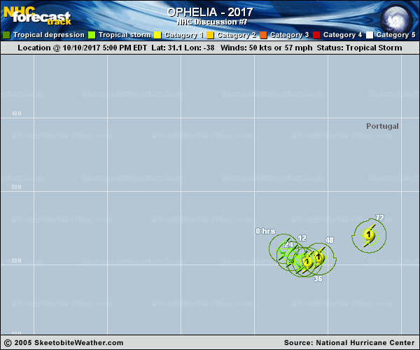
Copy of official data Tropical Storm Ophelia Discussion Number 7 NWS National Hurricane Center Miami FL AL172017 500 PM AST Tue Oct 10 2017 The overall convective structure of Ophelia has improved markedly over the past several, including the development of numerous, tightly curved bands and a burst of deep convection near the center. Upper-level anticyclonic outflow has also increased and expanded in all quadrants. Dvorak satellite current intensity estimates are T3.5/55 kt from TAFB and T4.0/65 kt from SAB, so the initial intensity has been conservatively increased to 50 kt. A 28-30 kt wind report from ship PBQL, located more 200 nmi northwest of the center, indicates that the outer circulation is also strengthening. The initial motion estimate is 135/04 kt. Ophelia is forecast to continue moving southeastward at a slow but steady pace for the next 48 hours or so while the cyclone remains embedded within a broad mid-/upper-level trough. The NHC model guidance remains in good agreement on the Ophelia beginning to lift out to the northeast by 72 h, and then gradually accelerate into the mid-latitude westerlies ahead of an eastward-moving mid-tropospheric trough. The latest model guidance remains tightly packed, but it has also shifted northward, which brings Ophelia closer to the Azores in the 96-120 hour period. However, the new forecast track was not shifted northward and remains along the southern edge of the guidance envelope between the NOAA HCCA consensus model and the more southerly ECMWF model. The GFS and ECMWF models continue to forecast only modest intensification for the next 48-72 hours, despite the vertical wind shear being fairly low at less than 10 kt. However, those models are forecasting more vigorous strengthening after 96 h as Ophelia experiences some baroclinic interaction, especially by 120 hours. The strong baroclinic deepening on day 5 could be overdone somewhat given that the best jetstream dynamics are forecast to be about 300 nmi northwest of the surface low and frontal zone. For now, the official intensity forecast remains similar to the previous advisory, and is little lower than the intensity consensus models HCCA and IVCN and the GFS and ECMWF solutions on days 4 and 5. FORECAST POSITIONS AND MAX WINDS INIT 10/2100Z 31.1N 38.0W 50 KT 60 MPH 12H 11/0600Z 30.6N 37.5W 55 KT 65 MPH 24H 11/1800Z 30.2N 36.8W 60 KT 70 MPH 36H 12/0600Z 30.2N 36.4W 65 KT 75 MPH 48H 12/1800Z 30.5N 35.6W 70 KT 80 MPH 72H 13/1800Z 32.0N 32.2W 70 KT 80 MPH 96H 14/1800Z 34.7N 25.8W 70 KT 80 MPH 120H 15/1800Z 39.0N 17.0W 70 KT 80 MPH...POST-TROP/EXTRATROP $$ Forecaster Stewart |