Official Discussion issued by the National Hurricane Center
Ophelia (AL172017) DATA RELEASED: 10/10/2017 11:00:00 AM UTC
|
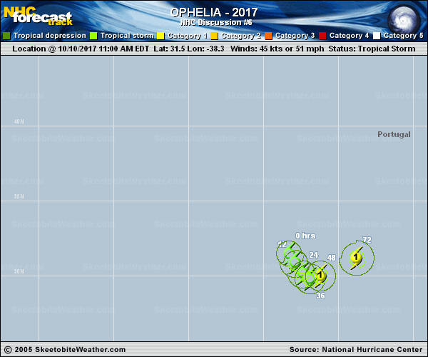
Copy of official data Tropical Storm Ophelia Discussion Number 6 NWS National Hurricane Center Miami FL AL172017 1100 AM AST Tue Oct 10 2017 Convective banding has continued to become better defined since the previous advisory, and an eye-like feature has developed in the center of the convection. However, despite the much improved satellite appearance, it appears that the increased convective organization has not yet translated into an increase in the surface winds based on a 1204Z ASCAT-B overpass, which only showed winds of 30-31 kt in the southern quadrant. Some undersampling is likely due to the small 25-nmi radius of maximum winds, and two nearby ships were under-sampled by at least 5 kt. Dvorak intensity estimates range from T2.3/33 kt from UW-CIMSS to T3.0/45 kt from TAFB to T4.0/65 kt from SAB. For now, the initial intensity will remain at 45 kt, which is an average of the scatterometer winds and all of the other available intensity estimates. Ophelia has been lumbering along slowly toward the southeast during the past 6 hours, and the initial motion estimate is now 130/04 kt. The latest model guidance remains in excellent agreement on the cyclone moving slowly toward the southeast for next 48 hours or so. By 72 hours, Ophelia is expected to turn northeastward and gradually accelerate into the westerlies ahead of a deep-layer trough. Since the NHC model guidance is tightly packed about the previous advisory track, only minor adjustments were made for this advisory. The intensity forecast isn't as straightforward as the track forecast due to the aforementioned differences in the intensity estimates. However, given that both the GFS and ECMWF models accurately predicted much lower intensity values of 35-40 kt for the 1200Z initial time period, a blend of those models were used to construct the intensity forecast for this advisory package. In addition to the slightly lower intensity forecast, the wind radii were also decreased both at the initial time and throughout the forecast period. FORECAST POSITIONS AND MAX WINDS INIT 10/1500Z 31.5N 38.3W 45 KT 50 MPH 12H 11/0000Z 30.9N 37.9W 50 KT 60 MPH 24H 11/1200Z 30.2N 37.4W 55 KT 65 MPH 36H 12/0000Z 29.8N 36.9W 60 KT 70 MPH 48H 12/1200Z 30.0N 36.2W 65 KT 75 MPH 72H 13/1200Z 31.2N 33.8W 70 KT 80 MPH 96H 14/1200Z 33.4N 28.5W 70 KT 80 MPH 120H 15/1200Z 36.0N 21.5W 70 KT 80 MPH...POST-TROP/EXTRATROP $$ Forecaster Stewart |