Official Discussion issued by the National Hurricane Center
Ophelia (AL172017) DATA RELEASED: 10/13/2017 11:00:00 AM UTC
|
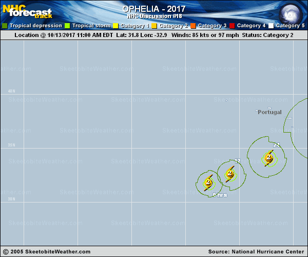
Copy of official data Hurricane Ophelia Discussion Number 18 NWS National Hurricane Center Miami FL AL172017 1100 AM AST Fri Oct 13 2017 The eye of Ophelia has become a bit more apparent in visible and infrared imagery during the past couple of hours, but the cloud tops around the eye have also warmed recently. The initial intensity is set to 85 kt based on a blend of the latest subjective and objective Dvorak CI and Final-T numbers. The hurricane will remain in an environment of marginal SSTs and light to moderate shear for the next day or so, which suggests little change in intensity during that time. By 36 hours, the shear will begin to increase as a powerful upper-level trough approaches from the west, but Ophelia should remain at hurricane force during extratropical transition as it undergoes a favorable interaction with the aforementioned trough and takes on a warm seclusion structure. The transition process is expected to be complete by 72 hours, and post-tropical Ophelia should gradually weaken as the cyclone occludes beneath the upper trough. The low-level circulation of Ophelia is expected to dissipate over Scandinavia by day 5. The initial motion estimate is 060/10. The track forecast reasoning remains unchanged from the previous advisory. Ophelia should move east-northeastward ahead of the approaching upper-level trough with a steady increase in forward speed through the next 24 hours. The hurricane should turn northeastward by 48 hours followed by a north-northeastward motion at days 3 and 4. The track model guidance is in good agreement on this overall scenario, but there are some differences in forward speed beyond 48 hours. The new NHC track is similar to the previous one and lies between the latest TVCA multi-model consensus and the HCCA corrected consensus aid through the forecast period. On this track, the center of Ophelia is expected to move southeast of the Azores during the next 36 hours and then move near or over Ireland and the western part of the UK in 3 to 4 days. Given the expected increase in the size of Ophelia's wind field during extratropical transition, impacts from strong winds and rain are becoming increasingly likely over portions of the British Isles regardless of the exact track of the center. While the NHC track continues to keep the center of Ophelia south and east of the Azores, tropical-storm-force winds are possible throughout the Azores beginning late Saturday or Saturday night due to an approaching cold front. Any deviation to the left of the forecast track could bring stronger winds to the islands. Interests in the Azores should refer to products issued by the Azores Weather Forecast and Watch Center. A 1242 UTC ASCAT-B pass was helpful in analyzing the 34-kt wind radii around Ophelia. KEY MESSAGES: 1. Ophelia is expected to become a hurricane-force post-tropical cyclone by Monday before it moves near Ireland and the United Kingdom. Direct impacts from wind and heavy rain in portions of these areas are becoming more likely, along with dangerous marine conditions. For more details on the magnitude, timing, and location of impacts from post-tropical Ophelia, residents in Ireland should refer to products issued by Met Eireann, and residents in the United Kingdom should refer to products issued by the Met Office. FORECAST POSITIONS AND MAX WINDS INIT 13/1500Z 31.8N 32.9W 85 KT 100 MPH 12H 14/0000Z 32.6N 30.9W 85 KT 100 MPH 24H 14/1200Z 34.1N 27.3W 85 KT 100 MPH 36H 15/0000Z 36.5N 22.6W 80 KT 90 MPH 48H 15/1200Z 40.7N 17.9W 80 KT 90 MPH 72H 16/1200Z 51.0N 11.5W 70 KT 80 MPH...POST-TROP/EXTRATROP 96H 17/1200Z 60.0N 4.0W 50 KT 60 MPH...POST-TROP/EXTRATROP 120H 18/1200Z...DISSIPATED $$ Forecaster Brennan |