Official Discussion issued by the National Hurricane Center
Nana (AL162020) DATA RELEASED: 9/1/2020 9:00:00 PM UTC
|
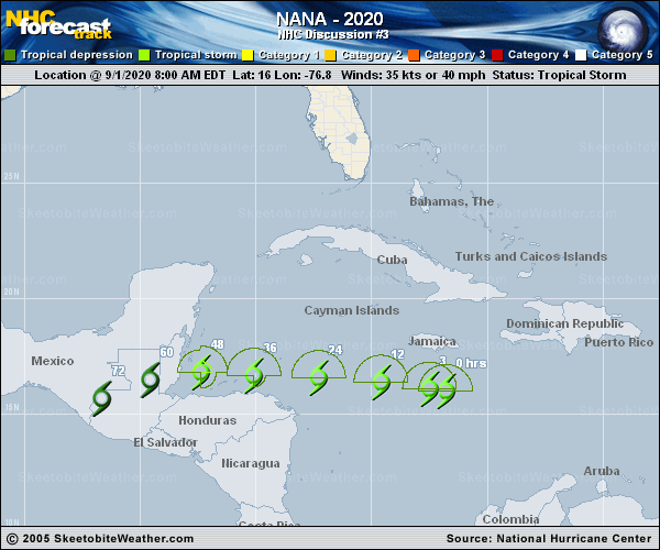
Copy of official data Tropical Storm Nana Discussion Number 3 NWS National Hurricane Center Miami FL AL162020 500 PM EDT Tue Sep 01 2020 Although convection has waned somewhat since the previous advisory due to mid-level dry air entrainment, Nana still has enough deep convection over and surrounding the low-level center to keep the intensity at 45 kt. Upper-level outflow has continued to improve, with the associated anticyclone becoming more symmetrical. Another reconnaissance mission is scheduled for this evening. The initial motion estimate is 275/16 kt. There are no significant changes to the previous track forecast or reasoning. A pronounced deep-layer to the north of Nana is forecast to remain intact and even build westward over the next few days, keeping Nana moving in a general westward direction for the next 36 hours or so. Thereafter, the aforementioned ridge is expected to build west-southwestward across southern Mexico, driving the cyclone west-southwestward as well across northern Central America. The new NHC forecast track is similar to the previous advisory track, and lies close to a blend of the simple consensus models TVCN and GFEX, and the corrected- consensus models NOAA-HCCA and FSSE. The current northeasterly 15 kt of vertical wind shear and dry air intrusions should inhibit development for next 24 hours or so. However, the GFS and ECMWF models both forecast the shear to gradually decrease during the next 48 hours, becoming near 5 kt by 36 hours. The lower vertical shear, coupled with the already impressive outflow pattern, sea-surface temperatures of 29.5-30.5 deg C, and a moistening mid-level environment should allow for gradual strengthening for the next 24 hours, followed by more significant intensification thereafter, which will continue right up until landfall occurs. The NHC official intensity forecast is a blend of the simple consensus intensity model IVCN, and the corrected-consensus models NOAA-HCCA and FSSE. A Tropical Storm Warning and Tropical Storm Watch have been issued for the southern portion of the Yucatan Peninsula and the Caribbean Sea coast of Guatemala, respectively. KEY MESSAGES: 1. Tropical Storm Nana is now forecast to be a hurricane as it approaches the coast, and interests in Honduras, Guatemala, Belize, and Yucatan should closely monitor the progress of this storm. Strong winds, dangerous storm surge and very heavy rainfall causing flash flooding are becoming more likely from Nana. FORECAST POSITIONS AND MAX WINDS INIT 01/2100Z 16.8N 79.3W 45 KT 50 MPH 12H 02/0600Z 17.1N 81.5W 50 KT 60 MPH 24H 02/1800Z 17.3N 84.7W 55 KT 65 MPH 36H 03/0600Z 17.2N 87.3W 65 KT 75 MPH 48H 03/1800Z 16.9N 89.4W 45 KT 50 MPH...INLAND 60H 04/0600Z 16.5N 91.7W 20 KT 25 MPH...POST-TROP/REMNT LOW 72H 04/1800Z...DISSIPATED $$ Forecaster Stewart |