Official Discussion issued by the National Hurricane Center
Nadine (AL152018) DATA RELEASED: 10/10/2018 11:00:00 PM UTC
|
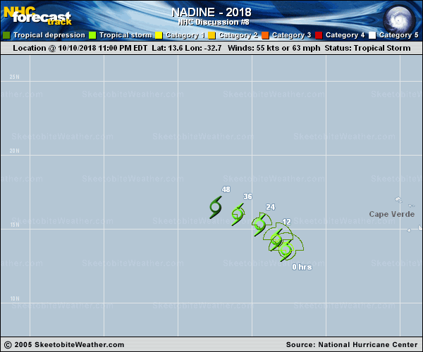
Copy of official data Tropical Storm Nadine Discussion Number 8 NWS National Hurricane Center Miami FL AL152018 1100 PM AST Wed Oct 10 2018 Another burst of deep convection has formed near the center of Nadine, which is typical in sheared tropical cyclones. A recent ASCAT pass indicated several believable 50-55 kt winds, so the initial intensity is held at 55 kt for this advisory. The shear is only forecast to increase over the next couple of days, which should lead to weakening, especially by Friday. All of the dynamical models indicate that Nadine will degenerate into a trough of low pressure over the weekend, and no significant changes were made to the previous forecast. Nadine continues to move northwestward due to a ridge near the Cabo Verde Islands. This general course is forecast for the next day or so until Nadine become a more shallow system, which should cause the cyclone to turn toward the west-northwest. The previous interpolated forecast came in basically on top of the new consensus and corrected-consensus guidance, so the new track forecast is very close to the previous NHC prediction. FORECAST POSITIONS AND MAX WINDS INIT 11/0300Z 13.6N 32.7W 55 KT 65 MPH 12H 11/1200Z 14.3N 33.4W 50 KT 60 MPH 24H 12/0000Z 15.3N 34.5W 40 KT 45 MPH 36H 12/1200Z 16.0N 36.0W 35 KT 40 MPH 48H 13/0000Z 16.5N 37.5W 30 KT 35 MPH 72H 14/0000Z...DISSIPATED $$ Forecaster Blake |