Official Discussion issued by the National Hurricane Center
Nadine (AL152018) DATA RELEASED: 10/9/2018 5:00:00 PM UTC
|
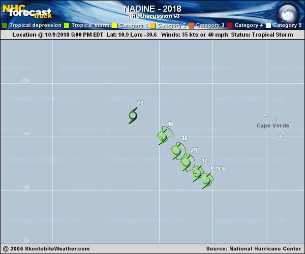
Copy of official data Tropical Storm Nadine Discussion Number 3 NWS National Hurricane Center Miami FL AL152018 500 PM AST Tue Oct 09 2018 Nadine is a sheared tropical cyclone this afternoon with the center partially exposed on the southwestern side of an increasing area of convection. Dvorak estimates are unchanged since earlier, so the initial wind speed remains 35 kt. The shear is forecast to remain low enough to support strengthening during the next day or so, along with sufficiently warm waters. However, Nadine should encounter a large upper trough after that time, which should cause weakening to begin on Thursday. Later on, cooler SSTs and strong shear are expected to cause Nadine to degenerate into a trough of low pressure by the weekend. Model guidance is in fair agreement on this scenario, and the new NHC prediction is close to the previous one and the model consensus. Satellite imagery today shows that Nadine has turned rightward and is moving 300/7. A northwestward track should begin overnight and continue for the next few days due to steering from a mid-level ridge near the Cabo Verde Islands. A westward turn is expected beyond day 3 as Nadine becomes a shallow system and dissipates. The track forecast isn't super confident because it is somewhat dependent on the intensity. For example, a stronger cyclone like the GFS shows would have the potential to move more toward the north- northwest as it attempts to remain a vertically coherent system. Since Nadine isn't expected to get very strong, the official forecast will stay near or just south of the model consensus, which results in no significant change to the previous track forecast. FORECAST POSITIONS AND MAX WINDS INIT 09/2100Z 10.9N 30.6W 35 KT 40 MPH 12H 10/0600Z 11.6N 31.5W 40 KT 45 MPH 24H 10/1800Z 12.6N 32.5W 45 KT 50 MPH 36H 11/0600Z 13.7N 33.4W 40 KT 45 MPH 48H 11/1800Z 15.0N 34.7W 35 KT 40 MPH 72H 12/1800Z 17.0N 37.5W 25 KT 30 MPH 96H 13/1800Z...DISSIPATED $$ Forecaster Blake |