Official Discussion issued by the National Hurricane Center
Nadine (AL152018) DATA RELEASED: 10/12/2018 5:00:00 PM UTC
|
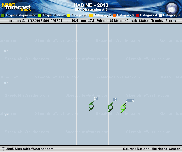
Copy of official data Tropical Storm Nadine Discussion Number 15 NWS National Hurricane Center Miami FL AL152018 500 PM AST Fri Oct 12 2018 The center of Nadine is now completely exposed to the west of a waning area of deep convection due to 35-40 kt of southwesterly shear. Based on a blend of the latest Dvorak CI and Final-T numbers from TAFB and SAB, the initial intensity has been reduced to 35 kt. This could be a little generous, but hopefully ASCAT will sample the system later this evening to provide a better idea of how much the winds have weakened. The NHC intensity forecast has been lowered from the previous one, and now shows Nadine becoming a depression by 12 hours and a remnant low by 24 hours, but both could happen sooner. The now shallow cyclone has turned west-northwestward, with an initial motion estimate of 285/13. Nadine and its remnants should move quickly westward in the low-level trade wind flow until dissipation. The new NHC track is close to the middle of the guidance envelope. FORECAST POSITIONS AND MAX WINDS INIT 12/2100Z 16.4N 37.7W 35 KT 40 MPH 12H 13/0600Z 16.5N 39.7W 30 KT 35 MPH 24H 13/1800Z 16.7N 42.7W 25 KT 30 MPH...POST-TROP/REMNT LOW 36H 14/0600Z...DISSIPATED $$ Forecaster Brennan |