Official Discussion issued by the National Hurricane Center
Marco (AL142020) DATA RELEASED: 8/24/2020 10:00:00 AM UTC
|
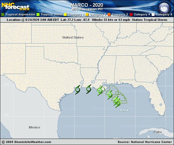
Copy of official data Tropical Storm Marco Discussion Number 17 NWS National Hurricane Center Miami FL AL142020 1000 AM CDT Mon Aug 24 2020 Strong southwesterly shear is taking its toll on Marco, with the edge of the nearest deep convection now displaced 50 n mi northeast of the exposed circulation center. Data from an Air Force Reserve Hurricane Hunter aircraft that investigated the system this morning measured 45-kt surface winds with the onboard SFMR instrument in that convection, but winds of only 20 to 30 kt were measured between this thunderstorm activity and the cyclone's center. Sampling by the aircraft has also revealed that winds of tropical storm force are likely no longer occurring in any portion of the circulation except in that convection. Based on the SFMR data, the initial intensity is initialized at 45 kt. The shear is not forecast to abate in the foreseeable future, and the simulated satellite imagery in the GFS and ECMWF suggests that Marco will degenerate into a remnant low on Tuesday. The latest NHC forecast is near the various consensus aids, which shows the cyclone weakening to a tropical depression late tonight. Based on the updated intensity forecast, tropical storm conditions are no longer expected to be produced by Marco over the central portions of the Louisiana coast, and the Tropical Storm Warnings for those locations have been discontinued. Marco has slowed down and has moved a little to the right of the forecast track over the past few hours, with an initial motion of NNW/7 kt. The track guidance for the entire forecast period has shifted back northward, and is just south of where it was this time yesterday. The official forecast track was adjusted eastward in the near term to accommodate the recent right-of-track bias. After 12 h, the track forecast lies between the previous one and most of the consensus track guidance. On this track, Marco is expected to move inland tonight, and remain inland when the system turns west-northwestward in the low-level flow by Tuesday morning. Key Messages: 1. Gusty winds, dangerous storm surge, and heavy rainfall are expected from Marco along portions of the Gulf Coast beginning later today. Interests in these areas should follow any advice given by local government officials. 2. Tropical Storm Laura could bring additional storm surge, rainfall, and wind impacts to portions of the U.S. Gulf Coast by the middle of the week. This could result in a prolonged period of hazardous weather for areas that may also be affected by Marco. Interests there should monitor the progress of Marco and Laura and updates to the forecast during the next few days. FORECAST POSITIONS AND MAX WINDS INIT 24/1500Z 28.5N 88.5W 45 KT 50 MPH 12H 25/0000Z 29.2N 89.3W 35 KT 40 MPH...INLAND 24H 25/1200Z 30.0N 91.3W 30 KT 35 MPH...POST-TROP/REMNT LOW 36H 26/0000Z 30.5N 93.6W 30 KT 35 MPH...POST-TROP/REMNT LOW 48H 26/1200Z 30.9N 95.9W 25 KT 30 MPH...POST-TROP/REMNT LOW 60H 27/0000Z...DISSIPATED $$ Forecaster Latto |