Official Discussion issued by the National Hurricane Center
Marco (AL142020) DATA RELEASED: 8/24/2020 4:00:00 AM UTC
|
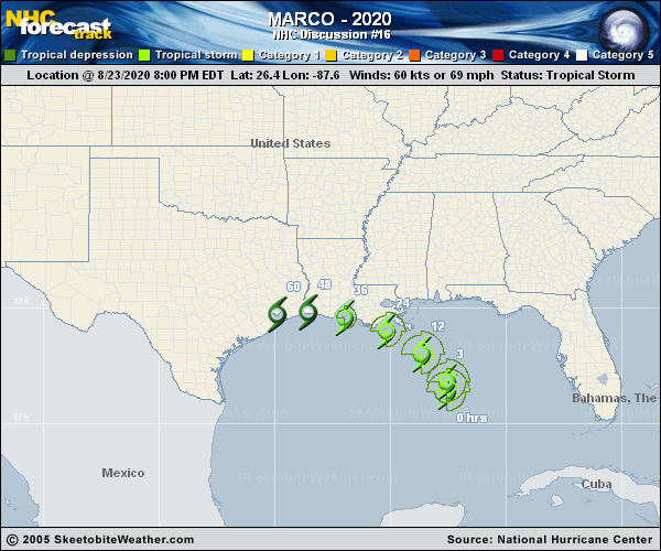
Copy of official data Tropical Storm Marco Discussion Number 16 NWS National Hurricane Center Miami FL AL142020 400 AM CDT Mon Aug 24 2020 Marco is clearly weakening tonight. Data from an Air Force Reserve Hurricane Hunter mission showed that flight-level and SFMR had decreased along with a substantial rise in central pressure. In addition, GOES-16 1-min satellite data show the surface center well displaced from the deep convection, and it appears that Marco is decoupling from its mid-level circulation to the northeast. The initial wind speed is set to 50 kt, and that could be generous. Some large changes have been required on this forecast. Considering the shear is only forecast to increase, there is no significant chance that Marco re-intensifies to a hurricane, and the hurricane warnings have been replaced with tropical storm warnings. Furthermore, now that the storm is losing vertical coherence, the intensity forecast has been decreased as well, and is fairly consistent with the model consensus and almost every model. Marco has turned northwestward this morning at about 9 kt. The storm should gradually turn westward as it approaches southeastern Louisiana due to the shallower cyclone feeling the low-level ridge. Marco will likely dissipate in a couple of days near the Texas/Louisiana border due to continued strong shear. Guidance has come into better agreement on the track going slightly inland or just brushing the Louisiana coast, and the track has been nudged southward on this advisory. It should be noted that the heaviest rain and strongest winds will likely be northeast of the center, so users should not focus on the exact track of the cyclone. Key Messages: 1. Gusty winds, dangerous storm surge, and heavy rainfall are expected from Marco along portions of the Gulf Coast beginning later today. Interests in these areas should follow any advice given by local government officials. 2. Tropical Storm Laura could bring additional storm surge, rainfall, and wind impacts to portions of the U.S. Gulf Coast by the middle of the week. This could result in a prolonged period of hazardous weather for areas that may also be affected by Marco. Interests there should monitor the progress of Marco and Laura and updates to the forecast during the next few days. FORECAST POSITIONS AND MAX WINDS INIT 24/0900Z 27.6N 88.2W 50 KT 60 MPH 12H 24/1800Z 28.6N 89.2W 45 KT 50 MPH 24H 25/0600Z 29.2N 90.8W 35 KT 40 MPH...INLAND 36H 25/1800Z 29.5N 92.7W 30 KT 35 MPH...OVER WATER 48H 26/0600Z 29.4N 94.5W 25 KT 30 MPH...POST-TROP/REMNT LOW 60H 26/1800Z...DISSIPATED $$ Forecaster Blake |