Official Discussion issued by the National Hurricane Center
(AL142018) DATA RELEASED: 10/12/2018 9:00:00 AM UTC
|
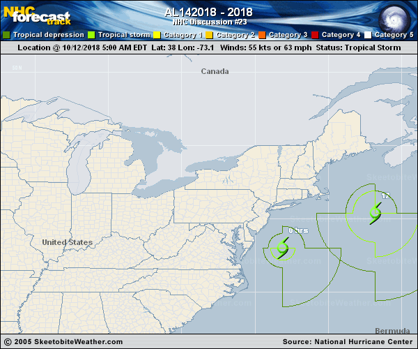
Copy of official data Post-Tropical Cyclone Michael Discussion Number 23 NWS National Hurricane Center Miami FL AL142018 500 AM EDT Fri Oct 12 2018 Satellite imagery and surface observations indicate that Michael has become a storm-force extratropical low as it moves off of the coast of the United States. The initial intensity has been increased to 55 kt based on the surface observations, and some additional increase in strength is expected during the next 12-24 h. After that time, the cyclone should gradually weaken, and it is forecast to dissipate over the eastern Atlantic by 96 h. The revised intensity and size forecast are based mainly on the guidance from the Ocean Prediction Center. The initial motion is 065/25. The cyclone should move very rapidly toward the east-northeast, followed by a more eastward motion near the end of the cyclone's life. This is the last public advisory issued by the National Hurricane Center on this system. Additional information on this system can be found in High Seas Forecasts issued by the National Weather Service, under AWIPS header NFDHSFAT1, WMO header FZNT01 KWBC, and available on the Web at https://ocean.weather.gov/shtml/NFDHSFAT1.shtml. Additional information on the remaining impacts over the United States can be found in products issued by local National Weather Service forecast offices. Key Messages: 1. Heavy rainfall may lead to flash flooding this morning from eastern New Jersey to southern New England. Elsewhere high water, flooding, and flash flooding may persist today where heavy rain fell very recently in the Carolinas and Mid-Atlantic states. 2. Gale-force winds will continue for a few more hours over portions of southeastern Virginia, the southern Chesapeake Bay, and the Delmarva Peninsula. FORECAST POSITIONS AND MAX WINDS INIT 12/0900Z 38.0N 73.1W 55 KT 65 MPH...POST-TROP/EXTRATROP 12H 12/1800Z 40.4N 66.8W 60 KT 70 MPH...POST-TROP/EXTRATROP 24H 13/0600Z 43.8N 55.5W 60 KT 70 MPH...POST-TROP/EXTRATROP 36H 13/1800Z 46.2N 42.0W 55 KT 65 MPH...POST-TROP/EXTRATROP 48H 14/0600Z 47.0N 28.5W 50 KT 60 MPH...POST-TROP/EXTRATROP 72H 15/0600Z 46.0N 11.0W 35 KT 40 MPH...POST-TROP/EXTRATROP 96H 16/0600Z...DISSIPATED $$ Forecaster Beven |