Official Discussion issued by the National Hurricane Center
Michael (AL142018) DATA RELEASED: 10/11/2018 3:00:00 AM UTC
|
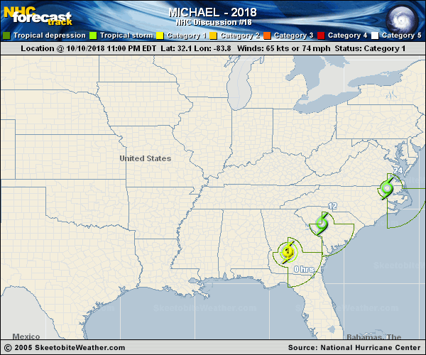
Copy of official data Hurricane Michael Discussion Number 18 NWS National Hurricane Center Miami FL AL142018 1100 PM EDT Wed Oct 10 2018 Data from NOAA WSR-88D Doppler weather radars indicate that Michael has been steadily weakening a a typical rate of decay since it moved inland. However, peak Doppler velocity values are still 80-85 kt between 5000-7000 ft above ground level in large areas in the eastern semicircle. With a recent burst of convection near the low-level center, some of those hurricane-force winds are likely making it down to the surface. Additional weakening is expected due to frictional effects, and the official intensity follows the trend of the Decay-SHIPS model for the next 24 hours while the cyclone remains over land. Sustained winds have dropped below tropical-storm-force across the northern Gulf coast, so the Hurricane Warning has been discontinued for that area. Michael is forecast to emerge over the western Atlantic Thursday night and Friday, where intensification as a robust extratropical cyclone is expected. The low is forecast to be absorbed by another low pressure area over the eastern Atlantic by day 5. The initial motion is now 045/17 kt. Michael will continue to accelerate northeastward as it becomes embedded within deeper mid-latitude southwesterly flow ahead of an eastward moving frontal system. By 36 hours, the expected post-tropical cyclone should turn east-northeastward and accelerate further while it moves over the north Atlantic. The latest track guidance is tightly clustered about the previous forecast track, so no significant changes were made. Gale- to storm-force winds are expected over portions of the Mid-Atlantic coast as Michael exits the U.S. east coast and becomes post-tropical. Non-tropical high wind watches, warnings, and advisories have been issued by local NWS offices for wind hazards in these areas north of Duck, North Carolina. Key Messages: 1. Life-threatening storm surge continues along portions of the Florida Panhandle and the Florida Big Bend. The worst storm surge is expected to continue between Panama City and Keaton Beach, where 3 to 5 feet of inundation is still ongoing. 2. Heavy rainfall from Michael could produce life-threatening flash flooding over portions of Georgia, the Carolinas, and southeastern Virginia. 3. Tropical storm conditions will affect portions of the southeast U.S. coast from northeast Florida through North Carolina, and tropical storm warnings are in effect for these areas. FORECAST POSITIONS AND MAX WINDS INIT 11/0300Z 32.1N 83.8W 65 KT 75 MPH 12H 11/1200Z 34.0N 81.5W 35 KT 40 MPH...INLAND 24H 12/0000Z 36.4N 77.1W 40 KT 45 MPH...INLAND 36H 12/1200Z 39.3N 70.3W 50 KT 60 MPH...POST-TROP/EXTRATROP 48H 13/0000Z 42.4N 60.8W 55 KT 65 MPH...POST-TROP/EXTRATROP 72H 14/0000Z 47.9N 35.9W 55 KT 65 MPH...POST-TROP/EXTRATROP 96H 15/0000Z 49.7N 13.1W 45 KT 50 MPH...POST-TROP/EXTRATROP 120H 16/0000Z...ABSORBED $$ Forecaster Stewart |