Official Discussion issued by the National Hurricane Center
Michael (AL142018) DATA RELEASED: 10/10/2018 10:00:00 AM UTC
|
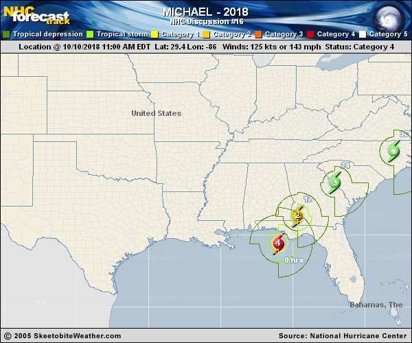
Copy of official data Hurricane Michael Discussion Number 16 NWS National Hurricane Center Miami FL AL142018 1000 AM CDT Wed Oct 10 2018 Michael is an extremely impressive hurricane in visible and infrared satellite imagery this morning. The eye has continued to warm and become even more distinct, while remaining embedded within an area of very cold cloud tops. Data from NOAA and U.S. Air Force Hurricane Hunter aircraft indicate that the pressure has continued to fall this morning and is now around 928 mb. Flight-level, SFMR, and NWS WSR-88D Doppler wind data all support an intensity of 125 kt. The hurricane only has a few hours left over water during which additional intensification is possible. Recent radar imagery suggest that an outer eyewall may be trying to form, and this could slow or halt the intensification process. Although steady weakening is predicted once the hurricane moves inland, the core of Michael will bring hurricane-force winds well inland over the Florida Panhandle, southeastern Alabama, and southwest Georgia. As the circulation emerges over the western Atlantic, intensification due to baroclinic process is expected, and Michael should complete its transition to an extratropical low by 48 hours when it is off the U.S. Mid-Atlantic coast. The system is predicted to remain a powerful extratropical cyclone over the north Atlantic through at least day 4. Aircraft and radar fixes show that Michael has made its much anticipated north-northeastward turn, and the hurricane is expected to make landfall along the coast of the Florida Panhandle early this afternoon. Michael should turn northeastward and begin to accelerate as it becomes embedded within the mid-latitude flow while moving across the southeast U.S. through Thursday night. The cyclone is forecast to emerge over the western Atlantic on Friday, and move rapidly eastward-northeastward across the north Atlantic this weekend. The track guidance remains in excellent agreement, and the updated NHC track forecast is very close to the previous advisory. Tropical storm warnings have been extended northward along the U.S. East Coast to Duck, North Carolina. Non-tropical watches, warnings, and advisories will be issued by local NWS offices for wind hazards north of Duck, North Carolina, as Michael is expected to be post-tropical when it affects those areas. Key Messages: 1. Life-threatening storm surge is occurring along portions of the Florida Panhandle, Big Bend, and Nature Coast. The worst storm surge is expected later today and tonight between Tyndall Air Force Base and Keaton Beach, where 9 to 14 feet of inundation is possible. 2. Michael will produce potentially catastrophic wind damage where the core of the hurricane moves onshore later today in the Florida Panhandle, with the highest risk between Apalachicola and Panama City. 3. Life-threatening hurricane-force winds will occur well inland across portions of the Florida Panhandle, southeast Alabama, and southwestern Georgia as the core of the hurricane moves inland later today and this evening. 4. Heavy rainfall from Michael could produce life-threatening flash flooding from the Florida Panhandle and Big Bend region into portions of Georgia, the Carolinas, and southeast Virginia. 5. Tropical storm conditions will affect portions of the southeast U.S. coast from northeast Florida through North Carolina, and tropical storm warnings are in effect for these areas. FORECAST POSITIONS AND MAX WINDS INIT 10/1500Z 29.4N 86.0W 125 KT 145 MPH 12H 11/0000Z 31.3N 84.7W 85 KT 100 MPH...INLAND 24H 11/1200Z 33.6N 82.1W 40 KT 45 MPH...INLAND 36H 12/0000Z 35.8N 78.0W 45 KT 50 MPH...INLAND 48H 12/1200Z 38.7N 71.6W 55 KT 65 MPH...POST-TROP/EXTRATROP 72H 13/1200Z 45.5N 52.5W 60 KT 70 MPH...POST-TROP/EXTRATROP 96H 14/1200Z 49.0N 29.0W 60 KT 70 MPH...POST-TROP/EXTRATROP 120H 15/1200Z 50.0N 13.0W 35 KT 40 MPH...POST-TROP/EXTRATROP $$ Forecaster Brown |