Official Discussion issued by the National Hurricane Center
Leslie (AL132018) DATA RELEASED: 10/11/2018 5:00:00 AM UTC
|
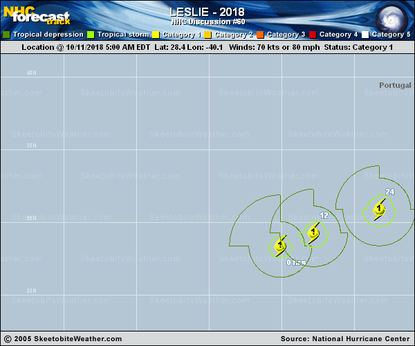
Copy of official data Hurricane Leslie Discussion Number 60 NWS National Hurricane Center Miami FL AL132018 500 AM AST Thu Oct 11 2018 The cloud pattern of Leslie has not changed significantly overnight. The hurricane has a large and ragged eye with deep convection most organized on its east side. The Dvorak CI-numbers are unchanged at 4.0/65 kt from TAFB and 4.5/77 kt from SAB, and based on these data, the initial intensity is held at 70 kt. Leslie will remain in low wind shear conditions and over relatively warm waters for another day or two, so little change in strength is expected during that time. Thereafter, the hurricane is forecast to move over waters as cool as 24 deg C and into an atmospheric environment of stronger shear and drier air. All of these conditions point to a weakening trend, which is likely to begin by the weekend. Most of the guidance shows a cold front approaching Leslie, but not quite merging with it so extratropical transition is not expected. However, it seems likely that Leslie will lose its convection and become a weaker post-tropical low in about 4 days. This scenario is supported by the latest runs of the GFS, ECMWF, and HWRF models. Leslie has made the expected east-northeastward turn with the latest initial motion estimated to be 065/9. This east-northeastward motion with an increase in forward speed is forecast to continue for the next 2 days while the steering pattern holds. After that time, however, it becomes much less clear. The models continue to struggle and keep changing their tune cycle to cycle on whether or not Leslie continues east-northeastward toward Morocco or Portugal, or gets left behind and moves west-southwestward due to a building ridge. The ensemble members of both the GFS and ECMWF favor the left behind (or southwestward) solution, and the NHC track forecast continues to lean in that direction. This forecast does show Leslie moving farther east before it makes the southwestward turn to be in better agreement with the latest consensus aids. FORECAST POSITIONS AND MAX WINDS INIT 11/0900Z 28.4N 40.1W 70 KT 80 MPH 12H 11/1800Z 29.3N 37.8W 75 KT 85 MPH 24H 12/0600Z 30.9N 33.3W 75 KT 85 MPH 36H 12/1800Z 32.1N 27.5W 70 KT 80 MPH 48H 13/0600Z 32.7N 22.3W 70 KT 80 MPH 72H 14/0600Z 31.3N 18.7W 50 KT 60 MPH 96H 15/0600Z 29.0N 19.5W 35 KT 40 MPH...POST-TROPICAL 120H 16/0600Z 27.5N 24.5W 30 KT 35 MPH...POST-TROP/REMNT LOW $$ Forecaster Cangialosi |