Official Discussion issued by the National Hurricane Center
Leslie (AL132018) DATA RELEASED: 10/9/2018 5:00:00 PM UTC
|
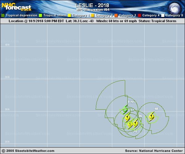
Copy of official data Tropical Storm Leslie Discussion Number 54 NWS National Hurricane Center Miami FL AL132018 500 PM AST Tue Oct 09 2018 Leslie's appearance on visible imagery has improved through the afternoon, and multiple microwave overpasses show the development of a small mid-level eye. The intensity has been increased to 60 kt based on an average of the most recent Dvorak classifications from TAFB and SAB. Leslie is moving over warmer waters and the wind shear is expected to be low, so additional strengthening is anticipated and Leslie is forecast to become a hurricane overnight. Given the relatively favorable environment and the recent organization of Leslie's inner-core, it is possible that Leslie could intensify a little faster than currently indicated by the NHC forecast. Beyond day 2, there is particularly low confidence in the intensity forecast since the track of Leslie is highly uncertain, and the NHC forecast essentially follows the intensity consensus. It is likely that the farther south and west Leslie remains, the stronger it will be. Unfortunately the track forecast has not become any clearer. Recent GFS and ECMWF ensemble forecasts still indicate that a range of possibilities exist, from Leslie becoming extratropical and heading toward the extreme northeast Atlantic, to Leslie turning back west in a few days and persisting as a tropical cyclone. No large changes were made to the track forecast at this time, since I see no reason to commit to a new solution at this time. The NHC forecast is close to HCCA at all forecast hours, but confidence is low to say the least. FORECAST POSITIONS AND MAX WINDS INIT 09/2100Z 30.3N 43.0W 60 KT 70 MPH 12H 10/0600Z 29.0N 42.6W 65 KT 75 MPH 24H 10/1800Z 28.0N 42.2W 70 KT 80 MPH 36H 11/0600Z 28.1N 41.4W 75 KT 85 MPH 48H 11/1800Z 29.2N 38.9W 75 KT 85 MPH 72H 12/1800Z 32.0N 29.5W 75 KT 85 MPH 96H 13/1800Z 33.0N 22.0W 60 KT 70 MPH 120H 14/1800Z 31.0N 20.0W 45 KT 50 MPH $$ Forecaster Zelinsky |