Official Discussion issued by the National Hurricane Center
Leslie (AL132018) DATA RELEASED: 10/8/2018 5:00:00 AM UTC
|
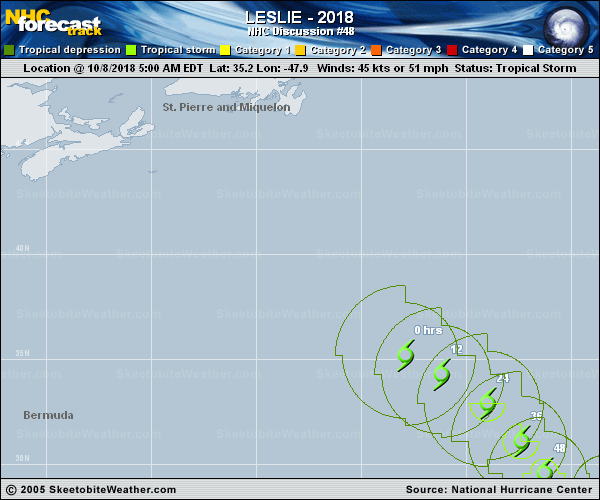
Copy of official data Tropical Storm Leslie Discussion Number 48 NWS National Hurricane Center Miami FL AL132018 500 AM AST Mon Oct 08 2018 There has not been a lot of change with Leslie overnight. Deep convection is still organized in curved bands near and to the north of the center, but there is some dry air entraining into the western side of the circulation. A blend of the latest satellite intensity estimates supports holding the initial intensity at 45 kt. Leslie is over cool 24 deg C waters, but it will be headed over slightly warmer waters during the next few days while remaining in low wind shear conditions. Therefore, slow strengthening is expected and most of the intensity models show Leslie reaching hurricane strength once again within the next 3 to 4 days. By the end of the period, cooler waters and an increase in shear could cause some weakening. The NHC intensity forecast is a little higher than the previous one, to trend toward the latest IVCN and HCCA guidance. Leslie is moving east-southeastward at 11 kt steered by the flow on the south side of a broad mid- to upper-level trough over the north Atlantic. An east-southeast to southeast motion is expected during the next couple of days as the trough passes by to the north of Leslie. After that time, another large-scale trough will approach Leslie from the northwest and that should cause the storm to turn east-northeastward at a faster pace in the 4 to 5 day time frame. The models have come into a better agreement this cycle showing a faster and more northward motion at the end of the period, and the NHC forecast has been adjusted accordingly. FORECAST POSITIONS AND MAX WINDS INIT 08/0900Z 35.2N 47.9W 45 KT 50 MPH 12H 08/1800Z 34.3N 46.2W 45 KT 50 MPH 24H 09/0600Z 32.9N 44.0W 50 KT 60 MPH 36H 09/1800Z 31.1N 42.4W 55 KT 65 MPH 48H 10/0600Z 29.6N 41.3W 60 KT 70 MPH 72H 11/0600Z 28.8N 38.3W 65 KT 75 MPH 96H 12/0600Z 31.2N 30.4W 70 KT 80 MPH 120H 13/0600Z 36.8N 20.0W 65 KT 75 MPH $$ Forecaster Cangialosi |