Official Discussion issued by the National Hurricane Center
Leslie (AL132018) DATA RELEASED: 10/5/2018 11:00:00 AM UTC
|
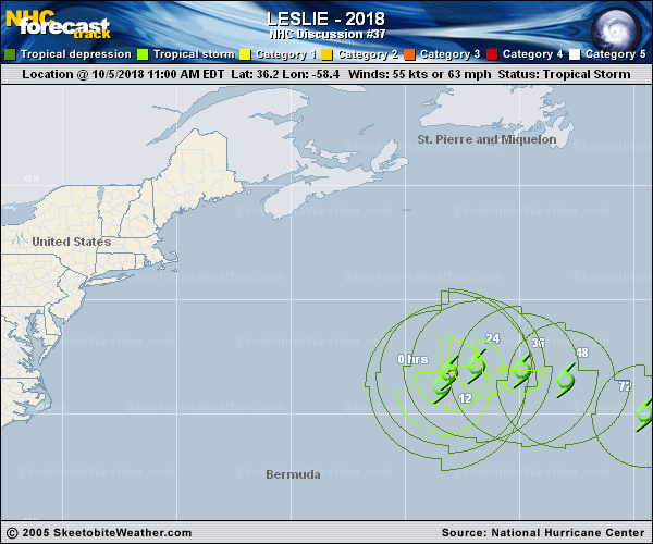
Copy of official data Tropical Storm Leslie Discussion Number 37 NWS National Hurricane Center Miami FL AL132018 1100 AM AST Fri Oct 05 2018 The structure of Leslie has changed little since the last advisory, with a cluster of convection just north of the low-level center and a second cluster well to the southeast of the center. The initial intensity is held at 55 kt based mainly on continuity from earlier scatterometer data, but it is possible that this is a little generous. It should be noted that overall, Leslie has lost some organization since this time yesterday due to the disappearance of the eye and an overall decrease in convective banding. Leslie appears to be slowing its forward speed, with the initial motion now 345/8. A turn to the north and a slower forward speed are expected during the next 12 h, followed by a turn toward the east-southeast by 36 h as Leslie encounters the southern edge of the mid-latitude westerlies. A general motion toward the east-southeast or southeast should then continue for the remainder of the forecast period. As noted in the previous advisory, there has been a southward shift in the guidance, and the new forecast track is again shifted a little to the south of the previous track. However, it lies to the north of the HCCA and TVCN consensus models. The forecast track takes Leslie over cooler waters around days 2-3, into increasing shear around days 3-4, and over warmer water with decreasing shear around days 4-5. However, the structure of Leslie is not currently conducive for rapid changes in intensity either up or down. Thus, the intensity forecast follows the trend of the previous forecast and the guidance in showing gradual weakening for 48-72 h, followed by slight intensification near 96-120 h. Large swells generated by Leslie are expected to continue during the next few days across the southeastern coast of the United States, Bermuda, the Bahamas, and the Greater and Lesser Antilles. These swells will also increase near the coasts of New England and Atlantic Canada later today. Please consult products from your local weather office as these conditions could cause life- threatening surf and rip currents. FORECAST POSITIONS AND MAX WINDS INIT 05/1500Z 36.2N 58.4W 55 KT 65 MPH 12H 06/0000Z 36.8N 58.1W 50 KT 60 MPH 24H 06/1200Z 37.1N 56.9W 50 KT 60 MPH 36H 07/0000Z 36.9N 54.9W 50 KT 60 MPH 48H 07/1200Z 36.5N 53.0W 45 KT 50 MPH 72H 08/1200Z 35.0N 49.5W 45 KT 50 MPH 96H 09/1200Z 33.0N 45.5W 50 KT 60 MPH 120H 10/1200Z 31.0N 42.5W 50 KT 60 MPH $$ Forecaster Beven |