Official Discussion issued by the National Hurricane Center
Leslie (AL132018) DATA RELEASED: 10/1/2018 5:00:00 PM UTC
|
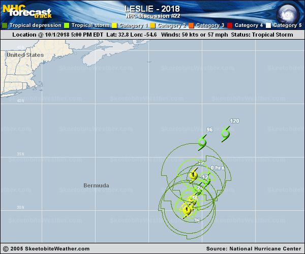
Copy of official data Tropical Storm Leslie Discussion Number 22 NWS National Hurricane Center Miami FL AL132018 500 PM AST Mon Oct 01 2018 The cloud pattern of Leslie has improved throughout the day, and the system now has a ragged eye with multiple mesovorticies within it. In addition, the associated convection has become more symmetric this afternoon, but the cloud tops are not very cold south of the center. Even though the system looks better organized, the satellite intensity estimates are again unchanged. Accordingly, the initial intensity is held at 50 kt near the high end of the satellite estimates. Leslie will likely strengthen gradually during the next day or so as it heads toward slightly warmer SSTs and remains in relatively low wind shear conditions. Most of the models show Leslie becoming a hurricane on Tuesday, and the NHC forecast follows that guidance. Leslie is expected to move north-northeastward back over its own upwelled cool waters late this week and this weekend, which should promote a gradual weakening trend. The NHC intensity forecast is identical to the previous one and in line with the HCCA and IVCN models. Leslie continues to drift to the southwest on the east side of a mid-level high. There has been no change to the track forecast philosophy. Leslie is expected to continue to move slowly southward to southwestward in weak steering currents during the next couple of days. Thereafter, a developing shortwave trough to the west of Leslie should cause it to move north-northeastward to northeastward at a slightly faster pace. The guidance has shifted south and west this cycle, and the NHC track forecast has been adjusted in those directions. Regardless of the details of the forecast track, there is high confidence that Leslie will meander for quite a while over the central Atlantic. Large swells generated by Leslie will continue to affect portions of the southeastern coast of the United States, Bermuda, the Bahamas, and most of the Greater and Lesser Antilles through tonight. These swells could cause life-threatening surf and rip currents. Although the swells will diminish slightly by Tuesday, they are expected to increase again over the Bahamas and most of the Greater and Lesser Antilles late Wednesday and Thursday. FORECAST POSITIONS AND MAX WINDS INIT 01/2100Z 32.8N 54.6W 50 KT 60 MPH 12H 02/0600Z 31.9N 55.4W 55 KT 65 MPH 24H 02/1800Z 30.9N 55.9W 65 KT 75 MPH 36H 03/0600Z 30.2N 56.2W 70 KT 80 MPH 48H 03/1800Z 30.0N 56.4W 70 KT 80 MPH 72H 04/1800Z 33.3N 55.8W 65 KT 75 MPH 96H 05/1800Z 36.4N 55.0W 60 KT 70 MPH 120H 06/1800Z 37.2N 52.8W 60 KT 70 MPH $$ Forecaster Cangialosi |