Official Discussion issued by the National Hurricane Center
Leslie (AL132018) DATA RELEASED: 9/29/2018 11:00:00 AM UTC
|
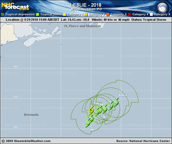
Copy of official data Subtropical Storm Leslie Discussion Number 13 NWS National Hurricane Center Miami FL AL132018 1100 AM AST Sat Sep 29 2018 Leslie's cloud pattern has taken on a more tropical appearance since last night. However, the cyclone is still co-located with an upper-level low, so its status as a subtropical cyclone is maintained for this advisory. The initial intensity remains 40 kt, based on a subtropical classification of 35-40 kt from TAFB. The global models forecast that Leslie will separate from the upper-level low over the course of the next day or so, which should complete its transition to a tropical cyclone. While this could result in a short-term increase in shear over Leslie, by early next week the cyclone will likely be located within a fairly low shear environment. However, Leslie is expected to move very slowly by that time, and ocean upwelling could limit or prevent further strengthening. There is a large amount of spread in the intensity guidance by day 5, but it is worth noting that the models most capable of properly representing the effect of ocean cooling on intensity, COAMPS-TC, HWRF, and HMON, all keep Leslie below hurricane strength for the next 5 days. The HWRF in particular forecasts nearly 5 deg C of ocean cooling beneath the cyclone. The NHC intensity forecast is generally a little lower than the previous advisory, but is still near the IVCN and HCCA consensus aids at all forecast hours. If Leslie moves more than expected, it would not be surprising if it strengthened more than currently forecast. Little change was made to the official track forecast. Leslie is still expected to move slowly southwestward for the next couple of days, before coming to a near halt early next week. By the middle of the week, an approaching mid-latitude trough could steer Leslie toward the north or northeast and allow the cyclone to start gaining speed, however, there is a lot of spread among the global models as to how quickly this will occur, and confidence in this portion of the forecast is fairly low. Large swells generated by Leslie when it was a strong extratropical low will affect Bermuda, the east coast of the United States, and most of the Greater and Lesser Antilles through the weekend. These swells could cause life-threatening surf and rip currents. FORECAST POSITIONS AND MAX WINDS INIT 29/1500Z 34.4N 50.8W 40 KT 45 MPH 12H 30/0000Z 33.8N 51.7W 45 KT 50 MPH 24H 30/1200Z 33.3N 52.7W 45 KT 50 MPH 36H 01/0000Z 33.1N 53.5W 50 KT 60 MPH...TROPICAL CYCLONE 48H 01/1200Z 32.8N 54.0W 50 KT 60 MPH 72H 02/1200Z 31.6N 55.0W 55 KT 65 MPH 96H 03/1200Z 31.0N 55.5W 60 KT 70 MPH 120H 04/1200Z 33.0N 55.0W 65 KT 75 MPH $$ Forecaster Zelinsky |