Official Discussion issued by the National Hurricane Center
Katia (AL132017) DATA RELEASED: 9/7/2017 4:00:00 PM UTC
|
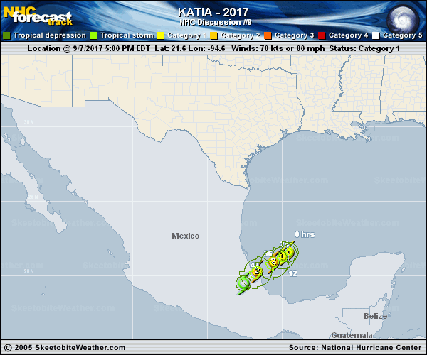
Copy of official data Hurricane Katia Discussion Number 9 NWS National Hurricane Center Miami FL AL132017 400 PM CDT Thu Sep 07 2017 Katia has changed little in organization since this morning, with limited convective banding features. An eye has not yet become apparent in satellite imagery. The current intensity is held at 70 kt which is roughly the mean of Dvorak estimates from TAFB and SAB. An Air Force Reserve Unit Hurricane Hunter aircraft is scheduled to investigate Katia this evening to check its intensity. Global models continue to show a well-developed upper-level outflow structure tonight and Friday, and strengthening is likely prior to landfall. The official intensity forecast is above the model consensus, and it is possible that Katia will approach major hurricane status prior to crossing the coast of Mexico early Saturday. Comparing afternoon satellite position estimates to reconnaissance center fixes from this morning, there does not appear to have been much motion today. A mid-level ridge is forecast to build to the north of Katia during the next day or so. This should cause Katia to move generally southwestward, and make landfall in Mexico in 36 hours or so. The official track forecast has been shifted just slightly southward and is mainly a blend of the latest simple and corrected consensus guidance tracks. FORECAST POSITIONS AND MAX WINDS INIT 07/2100Z 21.6N 94.6W 70 KT 80 MPH 12H 08/0600Z 21.3N 95.0W 80 KT 90 MPH 24H 08/1800Z 20.9N 95.6W 90 KT 105 MPH 36H 09/0600Z 20.3N 96.7W 90 KT 105 MPH 48H 09/1800Z 19.5N 97.6W 40 KT 45 MPH...INLAND 72H 10/1800Z...DISSIPATED $$ Forecaster Pasch |