Official Discussion issued by the National Hurricane Center
Katia (AL132017) DATA RELEASED: 9/7/2017 10:00:00 PM UTC
|
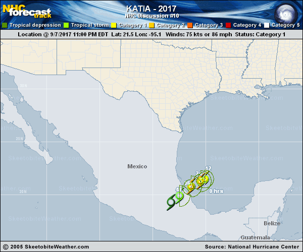
Copy of official data Hurricane Katia Discussion Number 10 NWS National Hurricane Center Miami FL AL132017 1000 PM CDT Thu Sep 07 2017 The Air Force Hurricane Hunters have been investigating Katia this evening and found flight level winds of 80 kt and SFMR values around 75 kt. Based on these data, the initial wind speed is nudged upward to 75 kt. Satellite images also show that Katia is getting better organized, with a ragged eye becoming apparent during the last hour or so. Additional strengthening is possible, and Katia could be near major hurricane strength before it makes landfall by Saturday morning. After landfall, rapid weakening is expected, and Katia is forecast to dissipate over the rugged terrain of the Sierra Madre mountains shortly after 48 hours. Katia has now begun the expected slow west-southwest motion. A continued slow west-southwestward motion is expected until the system dissipates. The NHC track forecast is similar to the previous one and near the consensus models. In addition to the hurricane-force winds, very heavy rains associated with Katia is forecast to affect eastern Mexico. These rains could cause life-threatening flash floods and mudslides. FORECAST POSITIONS AND MAX WINDS INIT 08/0300Z 21.5N 95.1W 75 KT 85 MPH 12H 08/1200Z 21.3N 95.5W 85 KT 100 MPH 24H 09/0000Z 20.8N 96.4W 90 KT 105 MPH 36H 09/1200Z 19.9N 97.5W 55 KT 65 MPH...INLAND 48H 10/0000Z 19.3N 98.3W 25 KT 30 MPH...INLAND 72H 11/0000Z...DISSIPATED $$ Forecaster Cangialosi |