Official Discussion issued by the National Hurricane Center
Kirk (AL122018) DATA RELEASED: 9/28/2018 5:00:00 PM UTC
|
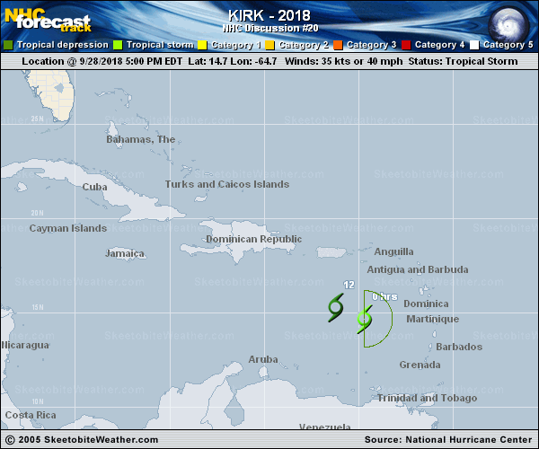
Copy of official data Tropical Storm Kirk Discussion Number 20 NWS National Hurricane Center Miami FL AL122018 500 PM AST Fri Sep 28 2018 Kirk is barely meeting the criteria for a tropical cyclone. The small low-level center is still exposed well to the west of most of the deep convection. The last fix from the earlier Air Force Reserve Hurricane Hunter mission found that the cyclone was still closed, but the maximum winds had decreased to near 35 kt. Since it seems likely that winds of this magnitude are still occuring in the convection to the east of Kirk, the system is maintained as a tropical storm for this advisory. Another reconnaissance mission is scheduled for tonight, and it should give a better estimate of the intensity of Kirk, and if the cyclone still has a well-defined surface circulation. No significant changes have been made to the track or intensity forecasts. Kirk is expected to move generally west-northwestward to northwestward over the next 12 hours or so while weakening due to the continued effects of strong westerly wind shear. By tomorrow morning, the cyclone will likely have degenerated into a trough of low pressure. Even though Kirk is weakening, heavy rains are expected over St Croix and eastern Puerto Rico during the next day or two while Kirk or its remnants pass to the south of those islands. FORECAST POSITIONS AND MAX WINDS INIT 28/2100Z 14.7N 64.7W 35 KT 40 MPH 12H 29/0600Z 15.3N 66.2W 30 KT 35 MPH 24H 29/1800Z...DISSIPATED $$ Forecaster Zelinsky |