Official Discussion issued by the National Hurricane Center
Jose (AL122017) DATA RELEASED: 9/20/2017 11:00:00 PM UTC
|
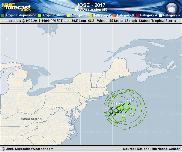
Copy of official data Tropical Storm Jose Discussion Number 63 NWS National Hurricane Center Miami FL AL122017 1100 PM AST Wed Sep 20 2017 There has been little overall change to Jose's cloud pattern since the previous advisory, as shallow convective bands remain over the northern and western portions of the circulation. Some of these bands are moving across portions of eastern Cape Cod, Martha's Vineyard, and Nantucket. The initial intensity has been reduced to 50 kt, which is supported by earlier aircraft data and a recent partial ASCAT pass that showed peak winds of 40-45 kt Water vapor imagery shows that the trough moving over eastern Canada has now passed to the northeast of Jose. As a result, the tropical storm is beginning to slow down. Jose is foreast to meander within weak steering currents over the next day or so. After that time, the cyclone is forecast to drift westward or southwestward as a ridge builds to the northwest and north of the cyclone over the weekend. There has been little change in the track guidance, and the new NHC forecast is essentially an update of the previous advisory. Cool sea surface temperatures, a drier mid-level airmass, and increasing westerly shear should result in gradual weakening during the next several days. Jose is likely to lose its remaining convection and become post-tropical in about 48 hours. The global models predict dissipation in 96 to 120 h, and the new NHC forecast follows suit. KEY MESSAGES: 1. While the center of Jose is forecast to remain offshore of the U.S. east coast, the large cyclone is expected to cause some direct impacts in portions of extreme southeastern New England during the next day or two, and a tropical storm warning remains in effect for Cape Cod, Block Island, Martha's Vineyard, and Nantucket. 2. Minor coastal flooding is possible along portions of the coast of southern New England during the next few days. Please see products issued by local National Weather Service forecast offices. 3. Swells generated by Jose are affecting Bermuda and much of the U.S. east coast and will likely cause dangerous surf and rip current conditions for the next several days in these areas. FORECAST POSITIONS AND MAX WINDS INIT 21/0300Z 39.5N 68.2W 50 KT 60 MPH 12H 21/1200Z 39.6N 67.7W 45 KT 50 MPH 24H 22/0000Z 39.5N 67.7W 45 KT 50 MPH 36H 22/1200Z 39.5N 68.5W 40 KT 45 MPH 48H 23/0000Z 39.4N 69.0W 35 KT 40 MPH...POST-TROPICAL 72H 24/0000Z 39.1N 69.4W 30 KT 35 MPH...POST-TROP/REMNT LOW 96H 25/0000Z 39.0N 70.2W 25 KT 30 MPH...POST-TROP/REMNT LOW 120H 26/0000Z...DISSIPATED $$ Forecaster Brown |