Official Discussion issued by the National Hurricane Center
Jose (AL122017) DATA RELEASED: 9/12/2017 11:00:00 PM UTC
|
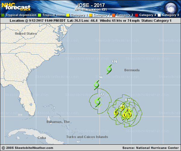
Copy of official data Hurricane Jose Discussion Number 31 NWS National Hurricane Center Miami FL AL122017 1100 PM AST Tue Sep 12 2017 Recent microwave imagery has revealed that Jose has a fairly sturdy structure, despite 20-25 kt of northerly shear. The hurricane has a well-defined mid-level eye, and a 2241 UTC WindSat pass shows a well-defined low-level circulation that is slightly eroded on the northwest side. Since Dvorak final-T numbers are 4.0 from TAFB and SAB, the initial intensity remains 65 kt, although it wouldn't be surprising if the winds were a little stronger than that. Jose could strengthen slightly during the next 12-24 hours while it remains in a regime of northerly shear, and models like the HWRF and HCCA support that thinking. After 24 hours, the shear is expected to turn out of the west-northwest and west directions, which are less likely to support intensification. Therefore, the NHC official forecast follows the trend of the intensity consensus (IVCN), showing Jose becoming a tropical storm on days 3 through 5. The ECMWF shows Jose encountering significant westerly shear by day 5, so it's possible that NHC forecast may be a little high toward the end of the forecast period. The microwave data indicated that Jose's center is a little more southeast than previously estimated, and the initial motion estimate is now 125/8 kt. Jose is being pushed southeastward on the back side of a large mid-latitude trough, but this trough will soon leave Jose behind with the subtropical ridge building in to its north. As a result, Jose is expected to make a slow clockwise loop during the next 3 days and then turn northward and northeastward once it moves around the western side of the ridge. Only the UKMET disagrees with this scenario by maintaining a persistent ridge to the north, and that model is discounted at this time. The NHC track forecast lies closest to a consensus of the GFS and ECMWF for most of the forecast period, and it's only a bit southwest of the previous forecast through day 3 to account for the updated initial position. FORECAST POSITIONS AND MAX WINDS INIT 13/0300Z 26.5N 66.4W 65 KT 75 MPH 12H 13/1200Z 25.9N 65.6W 70 KT 80 MPH 24H 14/0000Z 25.3N 65.3W 70 KT 80 MPH 36H 14/1200Z 25.2N 66.1W 65 KT 75 MPH 48H 15/0000Z 25.6N 67.4W 65 KT 75 MPH 72H 16/0000Z 27.3N 70.3W 60 KT 70 MPH 96H 17/0000Z 30.0N 70.5W 60 KT 70 MPH 120H 18/0000Z 32.5N 68.5W 60 KT 70 MPH $$ Forecaster Berg |