Official Discussion issued by the National Hurricane Center
Jose (AL122017) DATA RELEASED: 9/12/2017 5:00:00 PM UTC
|
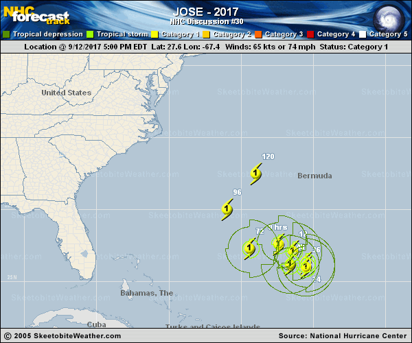
Copy of official data Hurricane Jose Discussion Number 30 NWS National Hurricane Center Miami FL AL122017 500 PM AST Tue Sep 12 2017 Jose's convective cloud mass has evolved from a rather shapeless one into a comma-type pattern today. This increased organization suggests that the cyclone is at least holding its own in terms of intensity. The advisory intensity of 65 kt is in agreement with a Dvorak T-number from TAFB and a Current Intensity number from SAB. The dynamical guidance shows moderate to strong shear, from varying directions, over Jose throughout the forecast period. The consensus of the intensity models shows little change in strength for the next 5 days, and so does the official forecast. This is a slight change from the previous forecast which called for Jose to weaken to a tropical storm within a day or so. Given the current trend toward better organization, however, Jose could easily intensify more than shown here. A slight repositioning of the working best track was done using a center fix from an excellent Windsat image from earlier today. The initial motion estimate is a little south of east or 100/6 kt. The GFS and ECMWF global models show a mid-level ridge building west, then north, and then east-northeast of Jose over the next few days. As a result, it is expected that the system will execute an anticyclonic loop over the next 72 hours or so. Later in the forecast period, Jose is forecast to turn northward and north-northeastward while moving through a break in the ridge. For unknown reasons, the U.K. Met. Office model track continues to be well west and south of the other guidance. The official forecast track favors the latest GFS and ECMWF solutions, but does not go as far to the north-northeast as the ECMWF near the end of the forecast period. FORECAST POSITIONS AND MAX WINDS INIT 12/2100Z 27.6N 67.4W 65 KT 75 MPH 12H 13/0600Z 27.1N 66.4W 65 KT 75 MPH 24H 13/1800Z 26.3N 65.5W 65 KT 75 MPH 36H 14/0600Z 26.0N 65.5W 65 KT 75 MPH 48H 14/1800Z 26.2N 66.6W 65 KT 75 MPH 72H 15/1800Z 27.3N 69.4W 65 KT 75 MPH 96H 16/1800Z 30.0N 71.0W 65 KT 75 MPH 120H 17/1800Z 32.5N 69.0W 65 KT 75 MPH $$ Forecaster Pasch |