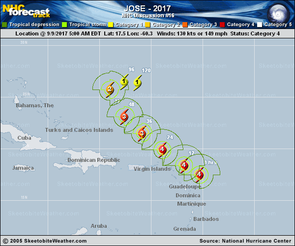
Official Discussion issued by the National Hurricane Center
Jose (AL122017) DATA RELEASED: 9/9/2017 5:00:00 AM UTC
|
Copy of official data Hurricane Jose Discussion Number 16 NWS National Hurricane Center Miami FL AL122017 500 AM AST Sat Sep 09 2017 There has been some weakening of the inner core this morning, specifically, considerable warming of the cloud tops and partial erosion of the western portion of the eyewall. Indications from earlier microwave passes and radar imagery from the Leeward Island of Guadeloupe reveal the possibility of an ongoing eyewall replacement cycle (ERC). Subsequently, the initial intensity is generously lowered to 130 kt for this advisory. An aircraft reconnaissance mission later this morning will provide a more accurate measure of Jose's intensity. Whether or not Jose completes the ERC cycle during the next several hours is uncertain. Regardless of the inner core structural transition, Jose is still forecast to be a category 4 hurricane as it closely approaches the northern Leeward Islands today. Statistical and dynamical intensity guidance show gradual weakening of the cyclone through day 5 as a result of increasing northerly shear and drier, more stable mid-tropospheric air associated with an approaching mid-latitude trough to the northwest of the cyclone. The official forecast is above all of the available guidance through 24 hours, then corresponds to the IVCN multi-model consensus. The initial motion is estimated to be west-northwestward, or 300/11 kt. The eye of Jose is expected to turn northwestward and pass just east of the northern Leeward Islands later today. Jose should slow down and turn north-northwestward in 72 hours in response to the aforementioned deep-layer mid-level trough. Large-scale models have come in alignment with the trough leaving Jose behind to meander in weaker mid-level westerly flow through day 5. The NHC forecast is basically an update of the previous package and is based on a blend of the HFIP Corrected Consensus model and the ECMWF. FORECAST POSITIONS AND MAX WINDS INIT 09/0900Z 17.5N 60.3W 130 KT 150 MPH 12H 09/1800Z 18.4N 61.8W 125 KT 145 MPH 24H 10/0600Z 19.9N 63.9W 115 KT 130 MPH 36H 10/1800Z 21.5N 65.9W 110 KT 125 MPH 48H 11/0600Z 23.1N 67.6W 100 KT 115 MPH 72H 12/0600Z 25.7N 69.0W 90 KT 105 MPH 96H 13/0600Z 26.5N 67.6W 80 KT 90 MPH 120H 14/0600Z 26.4N 66.3W 80 KT 90 MPH $$ Forecaster Roberts |