Official Discussion issued by the National Hurricane Center
Jose (AL122017) DATA RELEASED: 9/7/2017 11:00:00 PM UTC
|
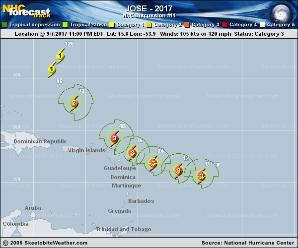
Copy of official data Hurricane Jose Discussion Number 11 NWS National Hurricane Center Miami FL AL122017 1100 PM AST Thu Sep 07 2017 After strengthening quickly throughout the day, the intensity of Jose appears to have leveled off this evening. Nonetheless, Jose is an impressive category 3 hurricane. The eye remains quite distinct and the convective cloud pattern is fairly symmetric. In addition, the upper-level outflow is well established, indicative of the favorable wind flow pattern aloft. The initial intensity is held at 105 kt, in accordance with the Dvorak CI numbers from TAFB and SAB. Some slight strengthening is possible during the next 12 to 24 hours while Jose remains in relatively conducive environmental conditions. Thereafter, a slow weakening trend is forecast due to an increase in wind shear and a progressively drier air mass. The models are in fair agreement, and the NHC official intensity forecast is in line with the consensus models. This forecast is slightly lower than the previous one. The initial motion is 280/16 kt. The track forecast philosophy is unchanged from earlier. A subtropical ridge should cause Jose to move west-northwestward for the next couple of days, taking the hurricane very near the northern Leeward Islands Friday night and Saturday. After that time, the hurricane is expected to move northwestward and then northward into a weakness in the ridge. The NHC track forecast is largely an update of the previous one and near the middle of the guidance envelope. Based on the latest forecast, the government of Antigua has issued a tropical storm warning for Antigua, Barbuda, and Anguilla. FORECAST POSITIONS AND MAX WINDS INIT 08/0300Z 15.6N 53.9W 105 KT 120 MPH 12H 08/1200Z 16.1N 56.1W 110 KT 125 MPH 24H 09/0000Z 16.8N 58.5W 110 KT 125 MPH 36H 09/1200Z 17.8N 60.5W 105 KT 120 MPH 48H 10/0000Z 19.2N 62.2W 100 KT 115 MPH 72H 11/0000Z 22.6N 66.1W 90 KT 105 MPH 96H 12/0000Z 25.8N 68.2W 75 KT 85 MPH 120H 13/0000Z 27.1N 67.4W 70 KT 80 MPH $$ Forecaster Cangialosi |