Official Discussion issued by the National Hurricane Center
Joyce (AL102018) DATA RELEASED: 9/18/2018 5:00:00 PM UTC
|
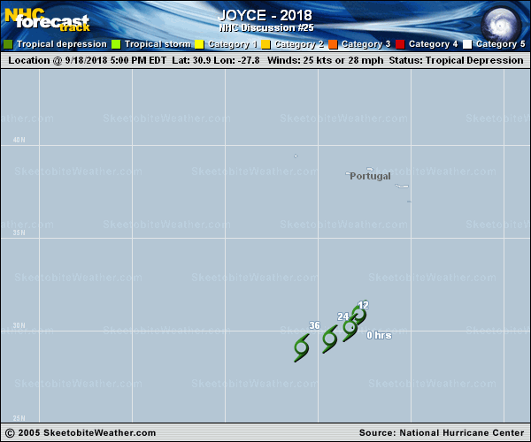
Copy of official data Tropical Depression Joyce Discussion Number 25 NWS National Hurricane Center Miami FL AL102018 Issued by the NWS Weather Prediction Center College Park MD 500 PM AST Tue Sep 18 2018 Deep convection has generally been on the wane during the past day or so near the center of Joyce, and it is getting very close to no longer having organized deep convection. With the decrease in overall organization, the initial wind speed is set to 25 kt. An environment of strong westerly vertical wind shear (30-40 kt) and marginal sea surface temperatures (around 25C) should cause Joyce to become a remnant low by late tonight or early Wednesday. This agrees well with the latest global model guidance, and the timing of remnant low status has been moved up to 12 hours (or less). The initial motion of Joyce continues to turn and is now south- southwestward (205 degrees at 6 kt). The depression is forecast to turn increasingly to the southwest and west as the central Atlantic ridge builds to the north. Model guidance, except the HWRF, is tightly clustered, so the new forecast track is essentially an update of the previous one, closest to the HCCA consensus model. FORECAST POSITIONS AND MAX WINDS INIT 18/2100Z 30.9N 27.8W 25 KT 30 MPH 12H 19/0600Z 30.2N 28.3W 20 KT 25 MPH...POST-TROP/REMNT LOW 24H 19/1800Z 29.6N 29.4W 20 KT 25 MPH...POST-TROP/REMNT LOW 36H 20/0600Z 29.1N 30.9W 15 KT 15 MPH...POST-TROP/REMNT LOW 48H 20/1800Z...DISSIPATED $$ Forecaster Campbell/Blake |