Official Discussion issued by the National Hurricane Center
Joyce (AL102018) DATA RELEASED: 9/18/2018 11:00:00 AM UTC
|
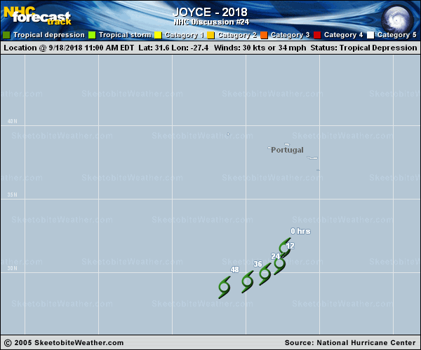
Copy of official data Tropical Depression Joyce Discussion Number 24 NWS National Hurricane Center Miami FL AL102018 Issued by the NWS Weather Prediction Center College Park MD 1100 AM AST Tue Sep 18 2018 Earlier in the morning, the low-level center of Joyce became decoupled from a small area of deeper convection. However, another convective burst has recently developed after 12Z closer to the low-level center. The initial intensity of Joyce was held at 30 kt based on a recent ASCAT pass, which showed an area of 25-30 kt winds on the north side of the circulation. The number of wind retrievals close to 30 kt was rather limited, so Joyce's winds should decrease below 30 kt when it eventually loses deep convection. The depression is in an environment with strong westerly vertical wind shear (30-40 kt) and marginal sea surface temperatures (around 25C), and thus the primary forecast question is when Joyce will succumb to the relatively hostile environment, lose deep convection and become a remnant low. The GFS and ECMWF models both show some deep convection lingering into tomorrow before warming upper-level temperatures and increasingly dry air aloft kill off any remaining convection. Therefore, the 12-hour forecast point maintains tropical depression status, and the 24-hour forecast point indicates a post-tropical system. The initial motion of Joyce is now more southerly (185 degrees at 7 kt), and it will begin to turn increasingly to the southwest and west as the central Atlantic ridge builds to the north. The new forecast track is essentially an update of the previous one, which was close to the TVCA and HCCA consensus models. Minor adjustments were made in the first 24 hours to account for a slightly faster observed motion to the south in the past 6-12 hours. FORECAST POSITIONS AND MAX WINDS INIT 18/1500Z 31.6N 27.4W 30 KT 35 MPH 12H 19/0000Z 30.6N 27.7W 25 KT 30 MPH 24H 19/1200Z 29.9N 28.7W 25 KT 30 MPH...POST-TROP/REMNT LOW 36H 20/0000Z 29.4N 29.9W 20 KT 25 MPH...POST-TROP/REMNT LOW 48H 20/1200Z 29.0N 31.5W 20 KT 25 MPH...POST-TROP/REMNT LOW 72H 21/1200Z...DISSIPATED $$ Forecaster Lamers/Blake |